 Ride with GPS (RwGPS) is a long-established and well-respected cycling app that majors on all-things-NAVIGATION. The web-based part of their platform has always been the most-featured part of their offering, yet there were significant updates to their iOS app earlier this year and today marks the day when the Android flavour is officially announced, even though it has already been live for a few days.
This post will briefly go through some of the new functionality and give some opinions. But first here’s a heads-up on some related points
- RwGPS is a major platform. If you haven’t got an account, it’s always worth grabbing a free one as you never know when it might come in useful. Despite sometimes finding the web interface to RwGPS a little bewildering in its complexity, I DO use RwGPS as the way to get my routes onto my Wahoo devices. Wahoo has a seamless “link and sync” functionality with routes from RwGPS which falls in the ‘just works’ category.
- On the previous point about ‘sometimes bewildering complexity‘, my recent chats with RwGPS have raised this…and they agreed! The point is that RwGPS are endeavouring to improve the user experience. So if you were scared away in the past then maybe consider it again next year (or try the app now!)
- The Ride with GPS app records Bluetooth sensor data. Now that STRAVA has stopped doing that, RwGPS could be a good alternative.
RwGPS – Mobile Route Planner
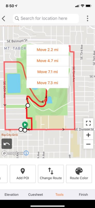
Today’s new features are linked mostly to the mobile route planner. Here they are
Route Deviation Detection
In this example, you can see I accidentally chose a side street (#ItWasDeliberate). However, when I select the next point along the route, the ‘spur’ into the side street is automatically removed. I’ve definitely done that before and usually, it’s relatively obvious when following the route what I needed to do to avoid the error in the route…but not always


#Handy. And yes, you can undo the autocorrection.
Overlapping Route Sections
In this example from RwGPS they have a route (course) where one segment is routed over 4 times. The new app allows you to effectively choose which of those overlapped sections you wish to edit.
Change Start and End Points

There are now multiple ways to change the start and endpoints of routes. In this example, you can see that I am significantly away from the route I want to follow yet it would be crazy to navigate to the start of the route. RwGPS lets me choose the point on the route where I wish to join the route.
I’m not sure how well they might automatically decide which is the best place to join the route. Most navigation platforms find that difficult to do well.
RwGPS – More General Thoughts
Here is my first attempt at creating a route on the mobile app. It starts from Pilgrim Cycles at Westhumble train station, mainly because they have very nice cake there (the coffee is not quite so good). The route then goes up the smooth-but-not-so-steep Box Hill where you can do your best to get a top-10,000 STRAVA segment place up what is a very popular hill in Surrey, UK.


The app was SMOOTH to use with good zooming and a choice of maps. It seemed to flow well and logically as well as having responsive “tap the map” action to create a routing point. You can see that an elevation profile is automatically created as is a turn-by-turn cue sheet.
As you can also see, there are different routing options and I would say that RwGPS is NOT perfect when it comes to creating the most sensible route for a cyclist as sometimes you have to force a segment to be chosen by using WALK mode and sometimes you want to avoid a tricky trail and might create the route in CAR mode. However, these are issues that are usually map-specific and so the ‘problem’ would be common to all software/apps using the same map.
Turning back to the 7 previous slides, I’ll point out one last thing about them. You can see I’ve created a series of imaginary coffee stops (POIs) both ON and OFF the route. The off-the-route POIs are stored in RwGPS’s route file and there are bikenavs, like the Hammerhead Karoo, which can then optionally route to and from the POI mid-route.
RwGPS – Some point from the company
I personally find that reading MANY company’s marketing literature and Press Releases is a thankless task. I get to the end and think…err…right, so what does it ACTUALLY REALLY DO? And…what’s ACTUALLY NEW. Typically, the marketing literature is just well-written gobbledygook. As I’ve said before, you could change the company name to another company name and you’d still be none the wiser.
Anyway. I got the following points from an email exchange with RwGPS. I like bullet points, so have a quick scan through this and you might get a better angle on the RwGPS’s ethos, usability aims and new app features.
Core ideas
- It should be fast
- Tap or search to route
- Tap anywhere on the route to edit
- Put common options close to where your thumb is
- Minimize the effort required for common tasks
- It should be easy
- Comprehensive undo/redo support
- Replace complicated tasks with smart features (change start/end, u-turn autocorrection)
- It should be powerful
- Zoomable, selectable elevation profile connected to map
- Compatible with the web-based route planner
- High-performance support for 1,000+ mile, complex routes
- Easy wireless sync with Wahoo devices and through Connect IQ App
Core features
- Tap on the map to route to a location
- Search for addresses, businesses, and locations to route to
- Route to and from current location
- Real-time, interactive elevation profile
- Climb-aware estimated riding time, based on your riding history
- Extended map options: Satellite, terrain, OSM Cycle, OSM Outdoor, ESRI, and more
- Add points of interest
- Change route colour to distinguish sections
Smart features
- Out and back
- Reverse route
- Change start/change end tool: Select location, and where along route to connect
- When rerouting an overlapping section (out and back, lollipop, multiple laps), get prompted to select which section to modify
- Accidental u-turn autocorrection: detects and corrects accidental taps slightly up side streets
Other Features
- privacy zones
- default ride/route settings
- ability to export your entire ride history at any time for input into another service
- ability to export files of routes and rides without needing an RWGPS account
- integrations with other services, such as Relive, automatic ride syncing to Strava, wireless route syncing to Wahoo devices, wireless route syncing to Garmin devices via Connect IQ app, and automatic ride syncing from Garmins via Garmin Auto Sync
Reader-Powered Content
 This content is not sponsored. It’s mostly me behind the labour of love which is this site and I appreciate everyone who follows, subscribes or Buys Me A Coffee ❤️ Alternatively please buy the reviewed product from my partners. Thank you! FTC: Affiliate Disclosure: Links pay commission. As an Amazon Associate, I earn from qualifying purchases.
![]()