plotaroute – Advanced Plotting Support, Now Integrated with Garmin
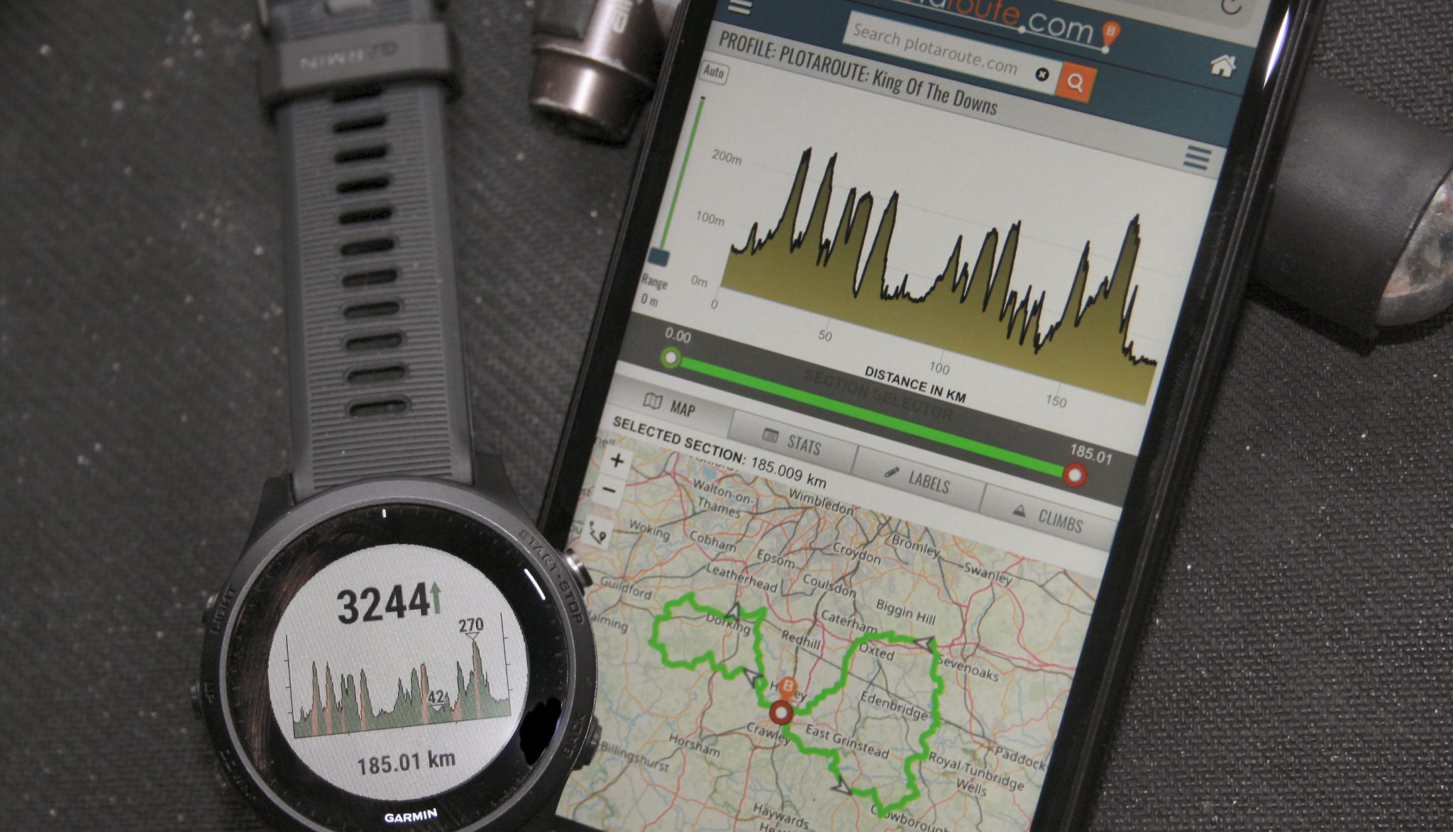
Today’s announcement sees another 3rd party linkup supporting Garmin’s COURSES API. This time it’s the uber-advanced route plotting tool plotaroute that is now fully linked up to Garmin Connect and onwards to your Edge, Fenix, Forerunner or other Garmin navigation device.
If you want to plot and share simple routes for your Garmin then there are 1001 solutions out there to do that, the most obvious being Garmin Connect! However, if you are the route-meister general in your walking, hiking, cycling or running group; if you are the one who slaves away on Saturday night to create that perfect route for an early morning Sunday group adventure then plotaroute might just be something to help you. If you do NOT like the clunky way you currently get routes to your Garmin from your favourite 3rd party routing app then plotaroute (and STRAVA and KOMOOT) offer a smoother, more seamless experience.
Even my limited route plotting needs have sometimes found technology lacking…I still recoil with horror at the thought of a long evening a few years ago – my inability to split a large route into two and then to combine one part of the split route with a 3rd route still lives with me to this day – I gave in. If only I had known about plotaroute then.
OK, you get the drift. I will briefly outline what plotaroute does as well as explain how the route sharing links in with the Garmin environment plus give a bit of background.
Garmin 3rd Party Routing and 3rd Party Workouts/Training Plans
A few years ago it was ‘big’ news when one activity/sports platform linked up to STRAVA to share workout data after you had completed your activity. I’m sure you’ll agree that is not news any more.
Garmin has taken the integration of our sports and activities to a new level over the last year or so and now the next levels of integration are to link your Garmin Forerunner/Fenix/Edge/Handheld to 3rd party route platforms and 3rd party coaching platforms and PULL stuff from them rather than sending completed workouts TO them, as has been the case historically. It just so happens that some 3rd party platforms like STRAVA want it both ways, they want completed workouts sending TO them AND they want courses/routes PULLing back from them…fine, that just confuses the picture of who is giving and who is taking in some people’s understanding.
Thus we’ve recently seen the like of TRAINING PEAKS and Final Surge let Garmin pull structured workouts from their coaching platforms and we’ve recently seen KOMOOT and STRAVA let Garmin pull routes from their routing platforms. These are two of the key trends in linking up sports and activity platforms that will continue for a few more years to come. As another example, Wahoo has had similar integrations for several years now.
Plotaroute has now used the exact-same abilities in the Garmin Connect platform that were used by KOMOOT & STRAVA to let their routes be sync’d through to Connect and onward to your device ready for your day’s adventures. There is NOTHING special or unusual about plotaroute’s use of the mechanism of the transfer nor the abilities contained in the route that is transferred. What IS special is HOW a complex route can be created with plotaroute and what is new is that it now can EASILY be sync’d through to your Garmin device.
PlotaRoute – What’s Special?
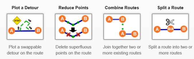
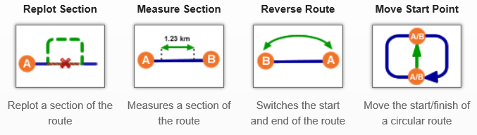
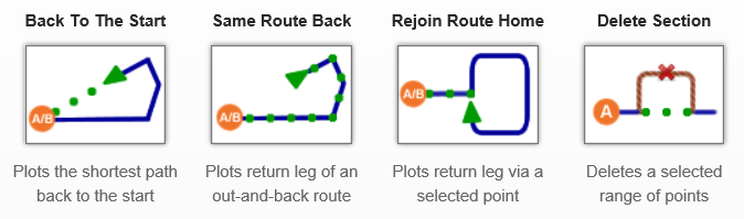
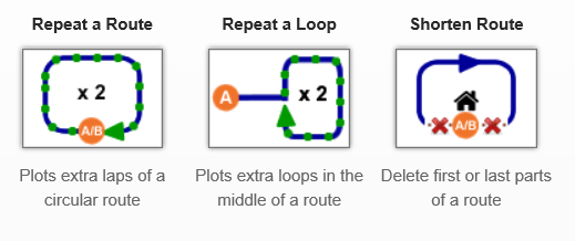
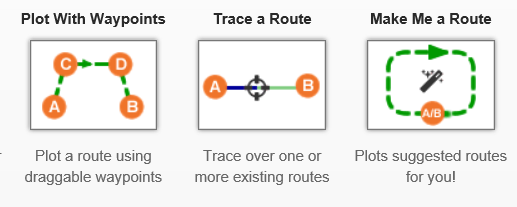
John at plotaroute.com has a tin. In the tin there is stuff and on the outside of the tin, it says EXACTLY what’s inside it. Hence PLOTAROUTE.com is just that. It’s a tool for plotting a route – albeit an advanced tool. As a quick overview here are the 18 plotting functions that plotaroute support which range from the simplification of plotted points through to route splitting and combining.
(smartphone: click the right arrow to see all)
Naturally, you can plot a new route based on advanced features that may affect your journey like
- Trails vs roads (walking vs cycling)
- Seeing Google Streetview alongside the map-route you are plotting
- Overlaying multiple routes on the map for comparison or for multi-day trip planning
- Detour management
- Gradient highlighting
- Route tagging
- Public Transport networks including formal cycle routes
- It can even show current road traffic conditions (but not running/cycling heatmaps)
- Naturally, Plotaroute creates Turn-By-Turn (TBT) instructions with street names, when available. However the Garmin API does not allow these to be received by Garmin so, instead, plotaroute sends Course Points with a limited 10 character turn instruction, normally a street name.
- And naturally, Plotaroute creates an elevation profile too.
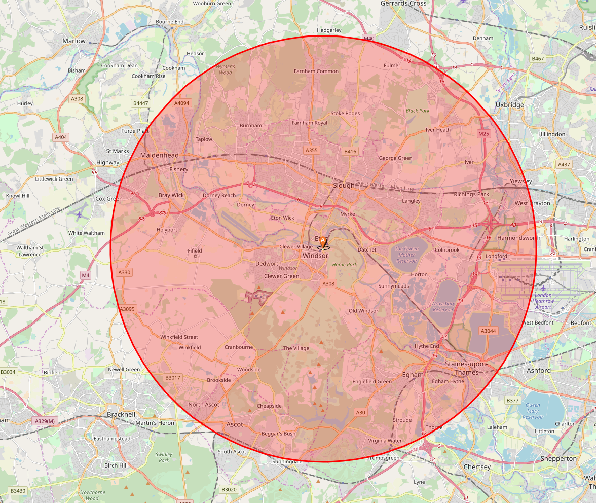
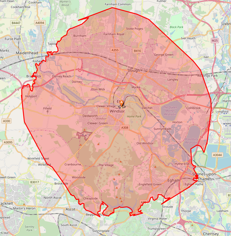
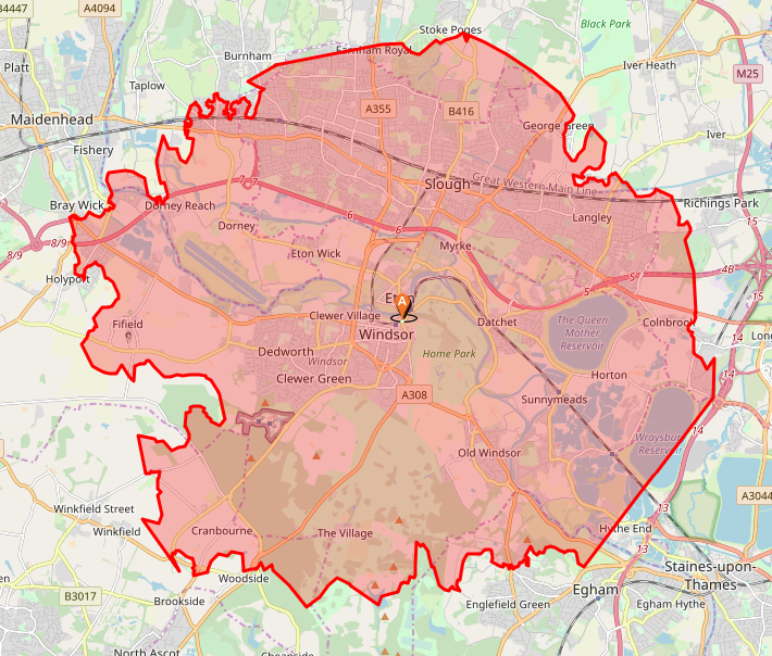
Finally here is one last route creation feature that I liked where you can quickly visualise a distance or time radius ‘as the crow flies’ from where you are. Fine. That’s easy enough. However, there is then an isochrone radius version which replots the boundary based on actual road mileage. I’ve shown both those below as 10km radii based on Windsor Castle, UK. The third image then factors the time taken when cycling to work out the limits of where I can get to within my constraints. I thought that was a nice tool that I could use when on holiday to visualise some limits of where I might want to cycle or run to before I set out. Try doing that on your premium STRAVA Account!
3 images, arrow right
Plotaroute clearly already has a great tool. Moving forwards perhaps they might somehow look to integrate heatmaps (route popularity data) both for route planning and route discovery purposes. Also, the tool is not an app but can be accessed and used as a web page on iOS/Android. Furthermore, I’m not sure if other companies like Wahoo will have the critical mass of users that might encourage plotaroute to invest in a closer integration (a la RwGPS +Wahoo and STRAVA+Wahoo) however detailed instructions do exist that relatively easily let you get a plotaroute route on your smartphone to your ELEMNT device (I haven’t checked but I would imagine there are instructions for other platforms too)
Garmin + plotaroute – What’s New
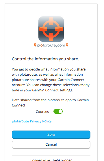
The link-up between BOTH the free and premium versions of plotaroute and Garmin Connect is ‘what’s new‘. It’s a 3-step process, namely:
- Authorize the connection from plotaroute to Garmin Connect
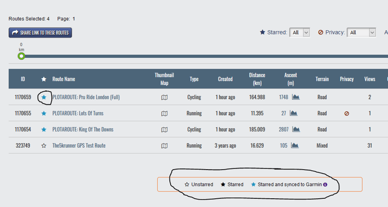
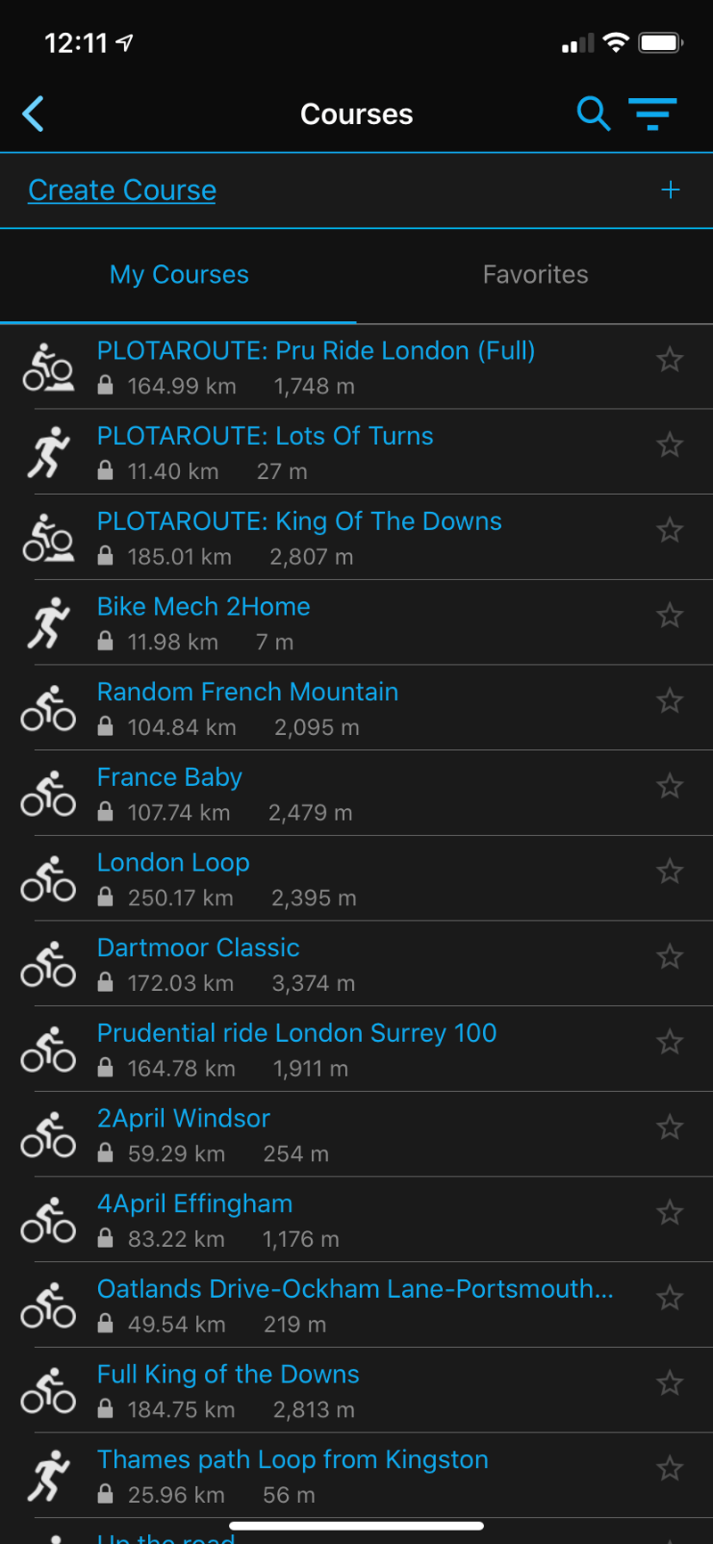
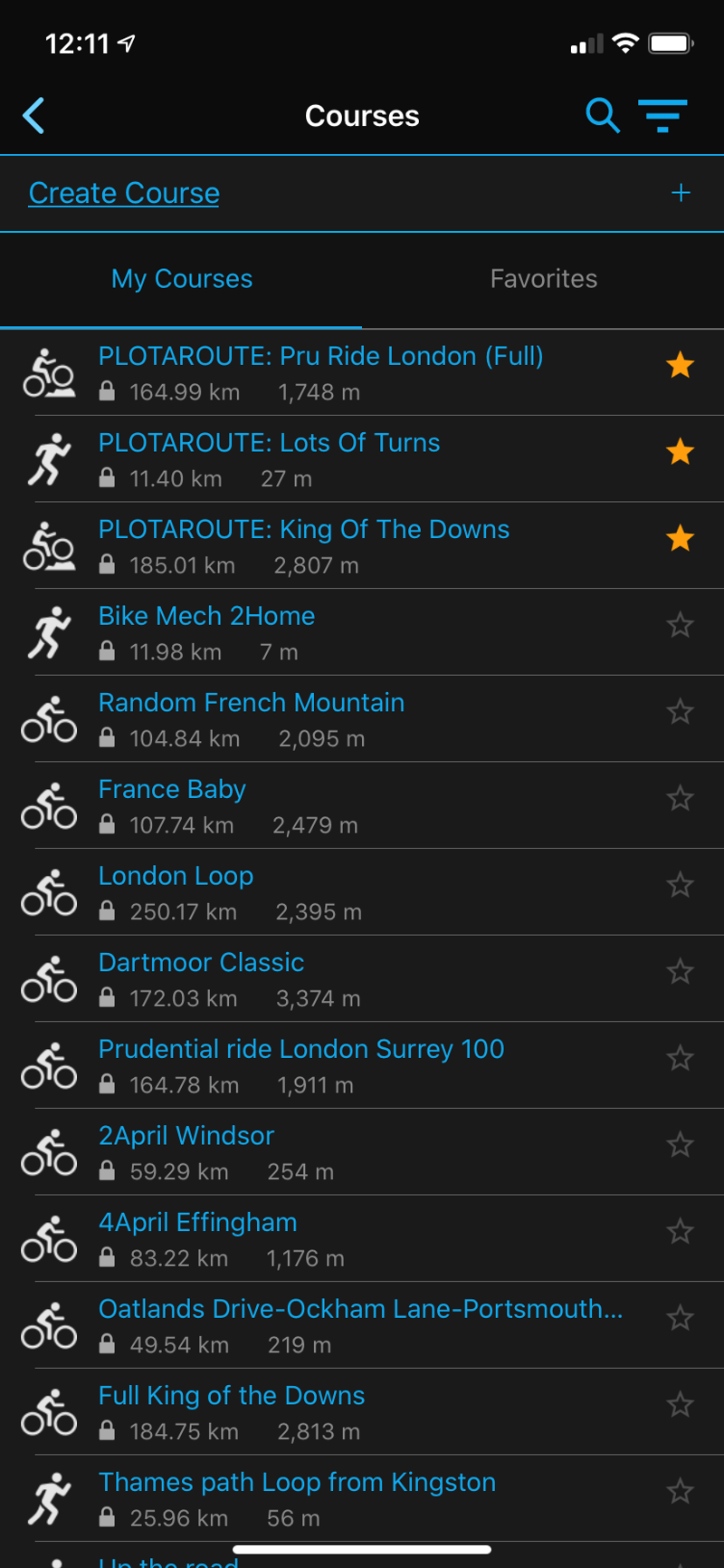
- ‘Favourite’ or ‘Star’ a route in plotaroute (it is automatically sync’d to your Garmin Connect Courses aka Routes)
- ‘Favourite’ or ‘Star’ your course in Garmin Connect (it is automatically/manually sync’d to all your Garmin devices)
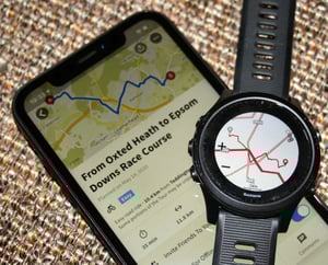
Within the Garmin platform, you can perform the ‘starring’ on either the web version or the smartphone version and you can sync to your Garmin device either by cable to your computer/Garmin Express or by the Bluetooth link to Garmin Connect Mobile on your smartphone. Same as Komoot/Strava. Here are some images of that process to give you a flavour.
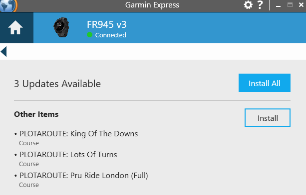
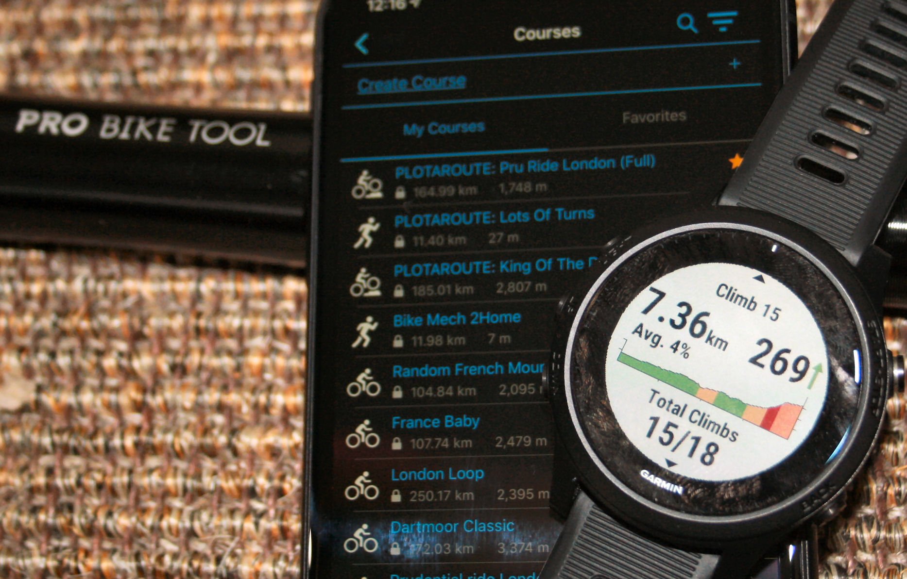
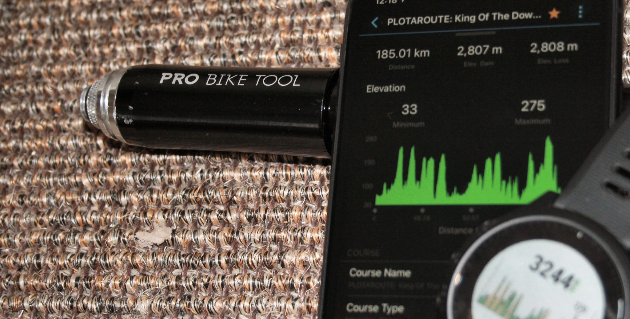
Eventually, as you can see on my Forerunner in the images below, the route is pushed successfully through – it takes a few 10s of seconds for the entire end-to-end sync.
Once started on the Forerunner, the route had all the route and elevation details I needed even for ClimbPro to properly work and produce the charts and stats for each upcoming climb. Cool!
UNstarring Favourites
The interesting part here with plotaroute is that, to me, it seems to work slightly differently from KOMOOT. When a route is UNstarred in plotaroute it is removed from Garmin Connect entirely, at least when the KOMOOT and STRAVA services were first launched I’m pretty sure that they left the route in Garmin Connect. Maybe that’s since changed? I’ll have to check.
Then, on the negative side, that unstarring is NOT carried through to the routes on the 945 ie they seem never to be automatically deleted from the 945. That’s fine in the short term but will build up the route list over time.
Limitations
My understanding from plotaroute is that the GARMIN API has limitations on what can be sent. POIs and full TBT instructions cannot be sent, although plotaroute have used course points as a partial workaround.
Many Garmin maps will already contain standard POIs.
The Garmin link is one of the PREMIUM features and costs GBP: £16, USD: $23, EUR: €19 a year
Take Out
This is a newsworthy story as plotaroute are one of the first companies to integrate with Garmin in this way and we will probably see several more follow suit in the months to come.
I was also slightly blown away with the plotaroute tool that seemed to me to offer capabilities that I’d not seen elsewhere – hence it’s seemed a good one to share.

Info: plotaroute.com
Disclaimer: This is an unpaid news story I get nothing from you selecting the links, I received a free 3-month premium trial that I will only use for the creation of this piece. I pay for the services and devices I use for my own personal use with my own money. If you want to support my work producing stories like this, which take a day to research write and test, then please show your support in one of the many ways available (link here).
Latest News – Garmin Edge 1030 Plus is Here – My Opinion below
Last Updated on 23 January 2026 by the5krunner
My favourite kit and nutrition
- Injinji – Runners protect your toes. Avoid discomfort and minor injury. Run more. Run faster. I use them.
- Garmin 90-degree charging adapter — The small adapter that keeps your charging cables tidy. Essential for race day. I use one.
- Garmin charging puck — the fastest and most reliable way to top up your Garmin before a session. I use one.
- Ravemen FR300 — Front light that mounts directly under your Garmin or Wahoo head unit. Keeps your bars clean and your beam pointed where it matters. I use one.
- Body Glide – The blue anti-chafe stick that all swimmers and many runners use. I use it.
- Maurten — The race nutrition trusted by elite athletes. Gels and drink mixes engineered to be easy on the stomach. I use them.
- Garmin Varia RTL515 — A radar rear light that alerts you to vehicles approaching from behind. Pairs with your Edge or Garmin watch. I use this model.
- Favero Assioma Pro RS2 — The power-meter pedals most serious cyclists choose. Accurate, easy to move between bikes. I use this model.
- Garmin Forerunner 970 — A serious choice for a pro-grade triathlon watch. I use this.
- Polar H10 — My daily driver for accurate, waking HRV readings.
- Wahoo ELEMNT Roam 3 — The bike computer that has the feature Garmin lacks: usability. I use mine on most rides.
Reader-Powered Content

This content is not sponsored. It’s mostly me behind the labour of love, which is this site, and I appreciate everyone who supports it.
Support the site: Follow (free, fewer ads) · Subscribe (paid, ad-free) · Buy Me A Coffee ❤️
All articles are written by real people, fact-checked, and verified for originality. See the Editorial Policy. FTC: Affiliate Disclosure — some links pay commission. As an Amazon Associate, I earn from qualifying purchases.
tfk is the founder and author of the5krunner, an independent endurance sports technology publication. With 20 years of hands-on testing of GPS watches and wearables, and competing in triathlons at an international age-group level, tfk provides in-depth expert analysis of fitness technology for serious athletes and endurance sport competitors. ID

I use OS Maps, you export the gpx file from the app directly into Garmin Connect and it all seems to work pretty flawlessly.
In few words – how would you compare it to Komoot?
komoot is prettier. plotaroute has more advanced route creation.
IIRC komoot has geographical limitations beyond which you need to pay.
Looks like only the Premium/paid version offers Garmin sync:
https://www.plotaroute.com/subscribe
I can confirm this as well, Plotaroute says Garmin linking is a premium feature.
yes The Garmin link is one of the PREMIUM features and costs GBP: £16, USD: $23, EUR: €19 a year
I have edited the main text to include that as well, ty for the heads up