Ride with GPS adds ground-level photo intelligence to its route planner
The gap between what a map shows and what a road delivers has long been one of cycling’s more tedious planning problems. Heatmaps help, but a surface marked as tarmac may be cracked and narrow. A trail rated as intermediate may be impassable after a wet spring. A climb flagged as scenic may top out in a commercial forest with nothing to recommend it. Ride with GPS has just launched a fully free feature to help address that.
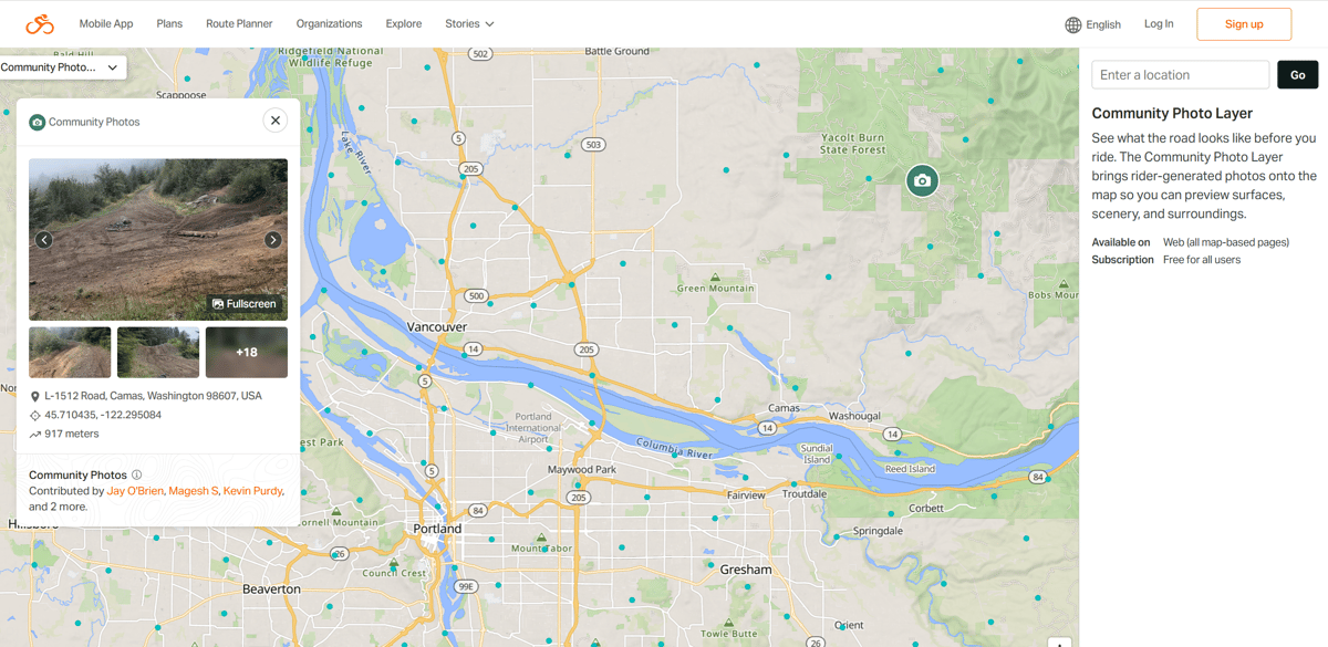
The Community Photo Layer is now available free to everyone and already brings more than 300,000 geolocated, timestamped, rider-generated photographs to the platform’s web-based map and route planner. Each image is pinned to its GPS location and includes a timestamp to account for seasonal fluctuations.
How the layer functions
Photographs appear as a cluster at a zoomed-out regional level and appear as individual markers as a planner narrows focus to a specific road or trail section. RwGPS’s rebuilt gallery view, below, accompanies the layer.
Automated image moderation removes, for example, images containing faces, leaving photographs focused on the planning task ahead – road surfaces, shoulder width, trail conditions, terrain character, and viewpoints.
Photos uploaded by riders that contain personal content remain visible within their own accounts but are excluded from the community layer. Similarly, riders can opt out of having their images shared via privacy settings, and a Report function routes flagged images to the moderation system for review.
Integration with the route planner means a photograph (location) can be added to a route as a waypoint with a single click — turning a visual reference into a part of the route without leaving the planning interface.
The photo layer sits alongside Ride with GPS’s existing pre-ride tools, such as surface type overlays, Community Highlights, and the Global Heatmap.
Where it stands against the competition
The concept is not new. Komoot introduced its Trail View feature in 2022, using machine learning to place rider-uploaded images within its route planner, with a particular emphasis on off-road surfaces. Of the approximately 15 million images uploaded to Komoot, the platform narrowed down the selection to approximately 1 million as suitable trail and path images for inclusion. By late 2025, Komoot’s redesigned platform was drawing on a library of over 87 million images. Trail View is available to all Komoot account holders at no cost via the desktop web interface, but it is not available in the mobile app.
Strava also introduced community photos in its route builder for subscribers, allowing images to be toggled to aid route creation. The feature draws on public photos to provide information on trail conditions, viewpoints, and tree coverage. It has, however, attracted consistent criticism from its own membership over the accuracy of photo locations.
The distinction in Ride with GPS’s implementation lies elsewhere: the single-click waypoint integration, the timestamped library, and availability across both the route planner and discovery pages — including on mobile — where Komoot’s Trail View does not reach.
Coverage and utility
The opening library of 300,000 photographs is modest against Komoot’s declared archive, and coverage will reflect the geographic distribution of the Ride with GPS membership, which skews towards North American road and gravel riding. For routes in well-ridden regions, the layer is likely to be genuinely informative to newcomers to the area. For remote or less-documented terrain, gaps will exist.
From the successes and limitations of Komoot and Strava’s similar implementations, RwGPS will likely find that event organisers, cycling travel operators, and guide services will benefit equally as much as riders and riding clubs.
More at ridewithgps.com.
Last Updated on 26 February 2026 by the5krunner
Reader-Powered Content

This content is not sponsored. It’s mostly me behind the labour of love, which is this site, and I appreciate everyone who supports it.
Support the site: Follow (free, fewer ads) · Subscribe (paid, ad-free) · Buy Me A Coffee ❤️
All articles are written by real people, fact-checked, and verified for originality. See the Editorial Policy. FTC: Affiliate Disclosure — some links pay commission. As an Amazon Associate, I earn from qualifying purchases.
tfk is the founder and author of the5krunner, an independent endurance sports technology publication. With 20 years of hands-on testing of GPS watches and wearables, and competing in triathlons at an international age-group level, tfk provides in-depth expert analysis of fitness technology for serious athletes and endurance sport competitors.
