Garmin Instinct 3 Marketing – Is Garmin Embarrassed to Show Navigation Features to Outdoor Adventurer Customers?
More: Garmin Instinct 3 Review – full and detailed
More: Garmin Instinct Series – all models, prices and 13-year history
After checking most of the promotional videos and images for the three Garmin Instinct 3 Series models released today, I could find only a single official image vaguely linked to maps and navigation. That’s it. One.
So, to answer the question posed in the title: YES, Garmin appears reluctant to highlight the navigation features of the Instinct 3 series. We all know why.
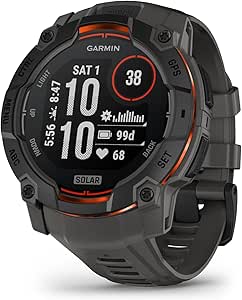
Frankly, this seems astonishing to me. Garmin is asking $450 for the Instinct 3 Solar, a premium price point for an outdoor-focused watch that lacks full mapping capabilities. Instead, the device relies on breadcrumb navigation — a feature that feels straight out of 2010. While Garmin has enhanced navigation slightly with a limited number of place names on the ‘map,’ as shown below, it’s far from the robust mapping experience many adventurers expect and need.

Contrast this with the Amazfit T-Rex 3 (review here), available for $235 at Walmart. It’s not a perfect product, but it boasts a colourful, detailed map and touchscreen interface. These features provide a visually appealing and functional navigation experience that far outpaces Garmin Instinct’s breadcrumb approach.
Yes, the T-Rex 3 has its issues, but “lacking a half-decent map” isn’t one of them. At nearly half the price of the Instinct 3 Solar, it’s hard not to question why Garmin hesitates to offer a similarly modern navigation feature set.
For outdoor adventurers, navigation is a critical feature. Garmin deliberately excluded maps, most probably to differentiate Instinct from the more expensive Fenix 8 range. In doing so, it committed the cardinal sin of exploiting some of its loyal customers.
Availability
The Garmin Instinct 3 series is available to order now with delivery after 10 January 2025
- Order: Garmin Instinct 3 AMOLED
Last Updated on 29 May 2026 by the5krunner
My favourite kit and nutrition
- Injinji – Runners protect your toes. Avoid discomfort and minor injury. Run more. run faster. I use them.
- Garmin 90-degree charging adapter — the small adapter that keeps your charging cables tidy. Essential for race day. I use one.
- Garmin charging puck — the fastest and most reliable way to top up your Garmin before a session. I use one.
- Ravemen FR300 — front light that mounts directly under your Garmin or Wahoo head unit. Keeps your bars clean and your beam pointed where it matters. I use one.
- Body Glide – The Blue anti-chafe stick that all swimmers and many runners use. I use it.
- Maurten — the race nutrition trusted by elite athletes. Gels and drink mix engineered to be easy on the stomach. I use them.
- Garmin Varia RTL515 — radar rear light that alerts you to vehicles approaching from behind. Pairs with your Edge or Garmin watch. I use this model.
- Favero Assioma Pro RS2 — the power meter pedals most serious cyclists end up choosing. Accurate, easy to move between bikes. I use this model.
Reader-Powered Content

This content is not sponsored. It’s mostly me behind the labour of love, which is this site, and I appreciate everyone who supports it.
Support the site: Follow (free, fewer ads) · Subscribe (paid, ad-free) · Buy Me A Coffee ❤️
All articles are written by real people, fact-checked, and verified for originality. See the Editorial Policy. FTC: Affiliate Disclosure — some links pay commission. As an Amazon Associate, I earn from qualifying purchases.
tfk is the founder and author of the5krunner, an independent endurance sports technology publication. With 20 years of hands-on testing of GPS watches and wearables, and competing in triathlons at an international age-group level, tfk provides in-depth expert analysis of fitness technology for serious athletes and endurance sport competitors. ID

Worse, the new Amazfit Active 2 features full colour maps, with labels, at USD99
i saw that briefly on Ray’s site…ouch!
I agree that Garmin prices have become inflated. At the top end they need to be a good £200 less, particularly with the onset of Samsung/Apple smart watches for less money that offer significantly better integration!
To the extent I could not justify upgrading to a Fenix 8 and instead use an Apple Watch Ultra 2, with my ‘old’ Garmin Forerunner 265 for fitness. Ideally I just wanted the Fenix 8, but thought the price increase, for very little beyond the 265, didn’t justify it. This way I also have some risk mitigation as I have two watches now, not a single one.
Plus the integrity of my AWU2, plus Apple Pay (I’ve tried Garmin Pay, it’s rubbish in comparison, mainly due to the lack of bank support and entering your pin), was worth it.
But in relation to this article, my question is; in reality does anyone actually navigate with their watch?
When I cycle I use a Garmin 1030 cycle computer, generally with pre-planned routes downloaded. It would be dangerous trying to use a watch!
For hiking/walking I tend to use Memory-Maps on my iPhone. But a phone is as small really as I want you go; zoom in enough to see the details and you lose the ‘bigger-picture’ of where you are going. Ideally I’d use an iPad Mini, so the larger screen can give me the detail, yet retain some perspective of the overall heading. But that’s getting spendy as you need the WiFi+Cellular model to gain the GPS.
I have thought about this and honestly could not see myself ever using the map on a watch, which lets face it, has a screen not much bigger than the end of your thumb.
To verify this, I’ve tried to use my AWU2 for navigating and concluded as fantastically clever as it is, it’s nothing more (to me) than pub bragging rights. If I needed to navigate I would simply use my phone.
In fact, I’ll be honest, where the AWU2 is better (again) then the Garmin is that the watch will link to Apple Car Play, and thus when you’re navigating with Apple Maps in the car, AWU2 will vibrate to warning of upcoming turns. It’s too small to look at and use, but the vibrating does prompt to look at the car screen. So as I generally have my car navigation silenced, this non-audible warning is useful. But Garmin maps on the watch would not offer this integrity, again justifying to me why they are too expensive.
I know with the Garmin you can tell it you want a (say) 5km run and it will plot you a route and guide you. But I don’t really know if I trust it to plot a route I’d want to run. Avoiding main roads, using alleys/parks, to create a loop, etc. Maybe I need to try that feature to gain confidence. But I fear it would be an expensive disappointment. In happy to just look at a map and workout a route then go run it, using the watch to track me and my stats – nothing more.
However in Gamins favour, their products are robust, built to last for years, have great battery life, fantastic GPS accuracy and general data collection.
Are these cheaper alternatives really as good?
Is this article the equivalent of: why would you buy a BMW 3-Series as it doesn’t come with (say) roof rails, yet the far cheaper Dacia does come with roof rails?
Thus ignoring the range, comfort, performance and every other conceivable improvement the BMW has.
I’ve sometimes learnt the hard way, particularly with tech and outdoor kit, buy cheap buy twice.
[quote]in reality does anyone actually navigate with their watch?[/quote]
I do. I am regularly trail running in mountain areas on new courses that I have preloaded. I also do this for mountain/trail races as well where courses are not always perfectly marked (or vandals mess with the markings).
It’s not just trail running either, I was literally running roads in Orlando last week with my wife and we ran into a part of a paved trail that was closed for construction. Because I had maps on my 965 I was able to quickly figure out an alternate route.
Garmin started out as a map company – it’s kinda telling that they have lost their way on this core function.
The maps on my Polar Vantage V3 are great. I’ve used them for runs in various cities when on holiday using Strava generated routes. Much easier to follow than a breadline in a city and no need to keep getting your phone out. Over the past 12 months I’ve used the maps in Copenhagen, Toronto, Budapest to name a few.