Garmin eTrex Touch – A Comprehensive Buyer’s Guide
Garmin’s next-generation eTrex Touch is a rugged GPS handheld navigator, introduced on September 30, 2025. It revives the fading Touch series, adding a vivid colour touchscreen plus significantly better mapping capabilities.
Garmin has designed this for you if you are an outdoor adventurer, occasional hiker, cyclist, or geocacher. Unlike a watch or bike computer, the eTrex Touch is designed to be clipped to a belt or rucksack when not held in your hand. Handy! Literally!
eTrex Touch is also a dedicated navigation device that will give you super-accurate positioning and a long battery life. Its rugged format protects it from knocks and bumps, and more importantly, your smartphone is kept safe in your backpack.
Another Garmin First to bear in mind when deciding on this product is that it comes pre-loaded with quality Garmin maps and the option to subscribe to more specialised ones (e.g. with contours). Garmin also bundles in its free Explore and Connect apps, which help with route creation and analysing your trip afterwards—both of these automatically link and sync to eTrex Touch.
eTrex Touch squarely sits at the centre of the Goldilocks Zone across Garmin's extensive Outdoor Ecosystem
Summary
eTrex Touch nicely meshes into Garmin’s extensive outdoor ecosystem. The overall experience is about more than just a handheld. You also get a vast number of on-device activity and mapping features, plus great recapping and reviewing features after the workout on Garmin Connect; from there, you link your endeavours back to Strava, Komoot or wherever. It’s the real deal. The complete deal.
Pros
- Free regional maps
- Open and expansive ecosystem
- Superior battery life
- Very good display
Cons
- Map contours need MAPS+ subscription
- Touchscreen-only interaction
- No solar
Display and Usability (The Touchscreen Experience)
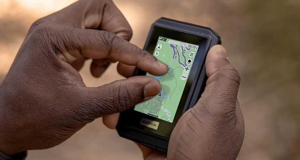
The touchscreen works in the same way as on your smartphone, so you can scroll, swipe, pan and pinch zoom to your heart’s content. More advanced features and options are also accessed similarly to your smartphone, with swiping down to open the settings menu.
Importantly, sports-grade touchscreens are now at the point where they generally handle rain much better than in years gone by. Which is a good job, as there are no buttons.
The 3″ colour display is pretty large by most standards, and with a 240x400px resolution, you will always get a sharp image. The tech used is transflective TFT – that’s a very techy phrase that means it uses a backlight in dark conditions but reflects light and the display image back in the day, saving energy.
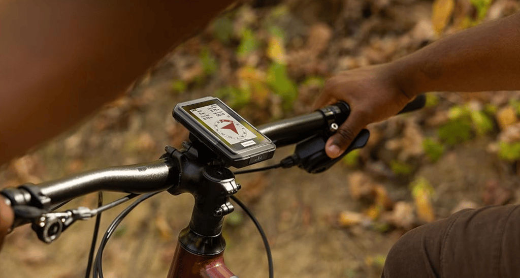
Garmin has considered the overall usability of this eTrex, with accessories for mounting on a bike and fastening to a lanyard or carabiner.
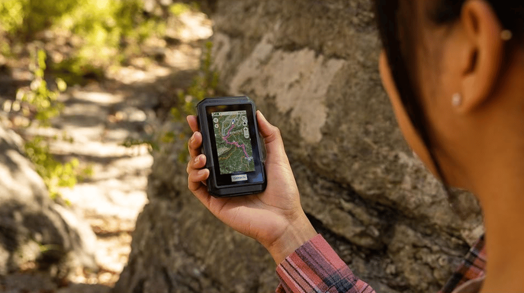
The size is great – it’s pocket-sized. We all love pockets. If you are looking for something slim and lightweight (150 g/5.3 oz), this is a good call.
When using for your activities. You will typically already have a personalised profile for each type – your cycling profile would be different to your hiking profile. Each has your preferred choice of metrics, maps, charts, and pointers, all chosen from a list too long to include here. If that sounds complicated, don’t worry, there are sensible defaults for each. (Creating or customising a profile is a little tricky, but do-able in 5-10 minutes).
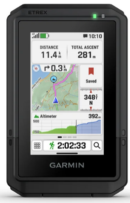
Here’s an example of a sensible screen layout, showing total time walked, distance walked, the route ahead, ascent and direction heading. The small map tile on the left indicates the route ahead in pink, and the elevation plot beneath the map shows there is still some climbing left to the top of the hill! Remember, each activity profile can have multiple pages; you swipe between them.
Mapping, Navigation, and Software Features
Before buying an eTrex Touch, it helps to understand what the pre-loaded mapping features can do for you and what they cannot. The bottom line is that it includes the features most people need, so you can skip this section if you are ‘most people’.
More Jargon – you get free TopoActive maps.
TopoActive Maps are Garmin’s version of the free OpenStreetMap data. Garmin adds an introductory level representation of the terrain, including roads, trails, and points of interest, but not specific details like footpath classifications and contour lines. These are especially suited to hiking and cycling-like activities, and the vital addition that Garmin has made that’s relatively unusual is that the maps are ‘smart’…meaning they are routable. This means that the maps you see are more than just pictures, so if you want to create a route on the map or re-route if you get lost, all the intelligence you need to get back on track is built into the eTrex. This is an unusual and important distinction from other brands’ maps, which are just a picture with a route line overlain – if you get lost there with them, the only options are to retrace your steps or navigate to a bearing.
I’ll point out a couple more goodies. Garmin has an extensive database of millions of completed routes from all over the world. This database is to offer you popularity-based choices, so you can follow the same paths most people use. It’s not guaranteed to be the perfect route, but there’s a very good chance it will be.
Then there’s round-trip routing. This is a longstanding Garmin feature, but still a bit buggy as I found this Summer. You say how far you want to go and in which rough direction (N, S, E, or W), and then Garmin routes for you. This is handy when you’re staying somewhere new and want to explore without the hassle of researching and curating a set of routes back to the same base point for your week’s stay.
Finally, there’s the dreaded ascent planning, too. When following a route, Garmin identifies the climbs/ascents you will encounter and presents each as an individual ascent. You can see all the metrics you want to—ascent to go, grade to go, and so on. Maybe when 1,000m of vertical ascent remains, it’s best not to know!
Nowadays, every product has a subscription offer, and eTrex Touch is no exception. You can opt for the Outdoor Maps+ subscription for ongoing access to premium content, such as high-detail elevation contours, high-resolution satellite imagery, land boundaries, and wildlife areas. However, for regular use cases, you don’t need that. Don’t subscribe to it unless you know you need it; plus, there are cheaper (free) non-Garmin alternatives which you can find with a bit of Googling.
Geocaching is fully supported, and if connected to a smartphone, Garmin updates the caches live. You also get the usual hints, history, and notes.
The eTrex touch has neat features for sharing saved locations and courses between devices or with friends. For example, you can easily pass a route to your Garmin watch or a friend’s Garmin handheld or bike computer. This is done directly between devices and not via the internet, so you can do it when off-grid.
Performance, Durability, and Accuracy Metrics
Garmin boasts some pretty impressive battery performance stats. You get 130 hours of per-second, high-quality GPS recording and can boost that to 650 hours in the expedition mode. Although that mode records position updates much less frequently, it works fine at walking speed.
650 hours! Was that a typo? A: No!
Q: How does Garmin do this when my smartphone battery lasts less than a day? Is there a catch?
A: No catch! eTrex Touch is an optimised navigation device. It has a relatively big battery, and, as we said above, its screen has a special energy-saving construction that phones don’t have. It also has the latest energy-efficient GPS.
A significant battery drain is GNSS/GPS; well, Garmin uses the latest satellite location chips from Synaptics. I’ve been testing these all year, and they are super accurate. They are market-leading, in fact. Garmin grabs positions from America’s GPS satellites, the EU’s Galileo and Russia’s GLONASS (together, they are referred to as GNSS). With so many satellites available, you can see why great accuracy is delivered.
It gets better. Some of those satellites send two dual-frequency GNSS signals, and Garmin interrogates their timings to determine if, for example, the signal has bounced off a canyon wall; if so, that satellite’s data is inaccurate and is discarded. Then it gets even better. That special dual-frequency mode uses more battery, so Garmin intelligently disables it with SatIQ when in normal reception conditions, and it’s not really needed.
eTrex has your ABCs covered – Altimeter, Barometer, compass
Is the elevation accurate?
Garmin’s elevation stats are generally accurate but are presented and stored differently, with pros and cons in each scenario.
How elevation works in Garmin-World
If you are following a route, Garmin takes any elevation data stored in the route but only uses it to display elevation charts and ascent. There is no guarantee this is accurate, but it is good enough for the chart. The places you get your routes from, like Strava or Komoot, will typically get elevation data from models that give an elevation for every latitude/longitude point, which is determined from satellite data. This data can be inaccurate when there are cliffs and sometimes when there is tree cover.
However, the situation is different when you are not following a route or even when following a route but looking onscreen at live elevation data (e.g. elevation not on a chart). Garmin determines your elevation according to some clever priorities and with the most reliable first, in this order: recent manual calibration, map (DEM) data, connected phone DEM, and finally, GPS.
The eTrex relies on precise barometric changes to determine elevation during your activity. Cross-referencing with GPS and map data periodically corrects this for weather-related drift.
I rate many of the eTrex’s other technical performance characteristics highly. The case is certified to an IP67 water rating and achieves a MIL-STD-810 impact-resistant specification. It has many onboard capabilities, including cable (USB-C), WiFi, Bluetooth Low Energy (BLE), and ANT+ for different kinds of communication to sensors, for uploading activities, and for downloading map updates.
Finally, 32 GB of storage is enough for regional maps and more.
Comparison: eTrex Touch vs. Its Siblings
Whilst the new eTrex Touch is better than its predecessors in almost every respect, it’s also more expensive.
Coming in at twice the list price of the eTrex solar (2023) gives pause for thought.
The new model simply looks better and more modern. Inside are more up-to-date components, and its screen is better. Oh, and the maps—that’s an obvious benefit. Even though the battery life is slightly lower than the Solar model due to powering a better-featured device, it is still excellent. This table nicely compares the three key models.
| Feature | eTrex Touch (2025) | eTrex SE (2023) | eTrex Solar (2023) |
|---|---|---|---|
| Display | 3-inch colour touchscreen (swipe/zoom) | 2.2-inch monochrome (button-only) | 2.2-inch monochrome (button-only) |
| Preloaded Maps | Yes (TopoActive, routable) | None (basic tracking only) | None (relies on app for maps) |
| Standard Battery | Up to 130 hours (Rechargeable Li-ion) | Up to 168 hours (2x AAA batteries) | Up to 200 hours (Rechargeable Li-ion) |
| Key Advantage | Detailed visual navigation and mapping | Highest expedition mode battery life (1,000 hrs) | Unlimited battery with solar exposure |
| MSRP (USD) | $449.99 | $199.99 (on sale: $149) | $249.99 |
Comparison Analysis
- vs. eTrex SE: The Touch is a significant boost for anyone needing visual navigation (maps and zoom), which SE lacks. $250 is a significant premium, but it gives you usability, a key feature.
- vs. eTrex Solar: Again, the Solar model lacks the usability of maps; the only reasons to get Solar are to save money and to support very long expeditions.
Pricing and Availability
At launch, Garmin has focused on delivering availability in the USA and UK, with EUR and the rest of the world to follow. Devices are available at Garmin.com, REI.com and some Amazon locales – all are linked below
- United States MSRP: $449.99 USD (includes North American TopoActive maps)
- International Pricing: Detail how the price varies by region due to taxes and exchange rates:
- United Kingdom (GBP): £389.99 (includes TopoActive Europe maps).
- Eurozone (EUR): €449.
- Canada (CAD): C$599.
- Australia (AUD): A$749.
Thoughts on eTrex Touch
This reinvigoration of the eTrex handheld line is super-interesting.
Garmin uses hardware similar to that used for its bike computers, and its software now seems to share standard features across many models. Thus, features like ClimbPro are reused for ascent planning when hiking, even though originally designed for cycling. This standardisation across Garmin’s entire range means bugs are released more quickly and new features are added more quickly. A Win – Win.
The standout addition at the $450 price point, for me, is MAPS. That’s an expensive yet significant level, as there is no current-generation Garmin outdoor watch with maps at a list price below $500. This perhaps partly explains why the Garmin Instinct 3 Series lacks maps—Garmin would like you to buy the maps you need with an eTrex and then hope to convince you to buy a partner watch like Instinct 3 AMOLED later down the line! Maybe!
Take Out – Benefits, Drawbacks, and Verdict
eTrex Touch squarely sits at the centre of the Goldilocks Zone across Garmin’s extensive Outdoor Ecosystem
eTrex Touch nicely meshes into Garmin’s extensive outdoor ecosystem. The overall experience is about more than just a handheld. You also get a vast number of on-device activity and mapping features, plus great recapping and reviewing features after the workout on Garmin Connect; from there, you link your endeavours back to Strava, Komoot or wherever. It’s the real deal. The complete deal.
The accessories are well thought through to address the practicalities of attaching to a belt buckle or rucksack, and the physical form factor is just right: excellent visibility, a decent size, and a durable case. Other than the price, that touchscreen is perhaps the only minor downside. It’s one of the better touchscreens, but you will find occasions when water, dirt, or sweat make using it a tad harder than you might see with a button.
In other reviews, I gently mocked Garmin for omitting Maps from its Instinct Outdoors watches—an uber-basic oversight. Now, eTrex Touch has added back maps as a necessary and welcome addition. People navigating need maps—at least that’s what I think! Maybe I’m old-fashioned.
| Benefits (Pros) | Drawbacks (Cons/Considerations) |
|---|---|
| Intuitive Colour Touchscreen: Easy map interaction (swipe and zoom). | Shorter Max Battery Life: The 650-hour expedition mode is less than the eTrex SE’s 1,000 hours. |
| Preloaded Mapping: Immediate access to routable TopoActive maps. | Higher Price Point: MSRP is significantly higher than the eTrex SE and Solar models. |
| Superior Accuracy: Multi-band GNSS support ensures high positional accuracy. | Outdoor Maps+ Subscription: Premium content like satellite imagery requires a separate paid subscription. |
| Extreme Durability: IP67 water rating and MIL-STD-810 impact resistance. |
eTrex Touch has everyone covered for virtually every outdoor adventure, especially those prioritising a rich navigation and routing ecosystem. It has the advanced features to help you support and enjoy your activities to the max.
I’d get one if you want a handheld GPS.
Other Resources
- Buy a Garmin eTrex Touch at a choice of retailer locations
- Official Product Page for Garmin eTrex Touch
- Official Garmin Press Release
- Beyond the Basics Video Explainer
- Garmin eTrex Touch Official Manual
With 20 years of testing Garmin wearables and competing in triathlons at an international age-group level, I provide expert insights into fitness tech, helping athletes and casual users make informed choices.
Reader-Powered Content
 This content is not sponsored. It’s mostly me behind the labour of love, which is this site, and I appreciate everyone who follows, subscribes or Buys Me A Coffee ❤️ Alternatively, please buy the reviewed product from my partners. Thank you! All articles are human-written, fact-checked, and verified for originality using Grammarly’s AI and plagiarism tools. See the Editorial Policy for details. FTC: Affiliate Disclosure: Links pay commission. As an Amazon Associate, I earn from qualifying purchases.
 ![]()

Where can I found more details on ‘Ascent Planner’. Searching for it only gives me the ‘ClimbPro’.
I’m considering this device for long distance cycling and like to know what’s ahead
sorry Bram. Grammarly had a double espresso last night and was let loose on this post. I’ve given it a good telling off. It’s ClimbPro
i was using a Garmin Oregon for hiking and cycling for many years but it was getting behind in features and battery life. Also started using only a garmin fenix / epix for hiking and recently got an edge 840 for bike touring. Any idea which edge cycling features will I loose by using the etrex in a cycling profile / activity ?
try this: https://tinyurl.com/3pu4cm46
its the more advanced performance phyiology features you lose, plus others