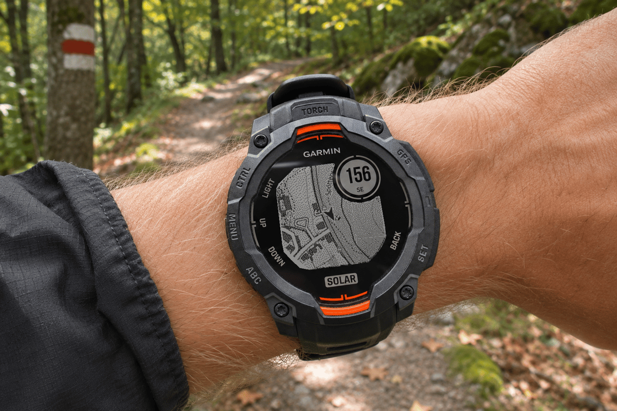
An Instinct owner steps off the marked trail and reaches a fork. The watch shows the loaded route as a breadcrumb line. The line shows where the route goes, but the screen gives little context about the paths on either side, the road beyond the trees or the stream ahead.
Battery life and a rugged case are good reasons to choose a Garmin Instinct, but no Instinct has onboard maps. On the supported Instinct 3 Solar and Instinct E models, OpenMaps adds a map beneath the route inside a Connect IQ app. Mo, the developer behind OpenMaps, built it so the watch can carry the map it needs for an outing and show it after the phone loses reception.
How OpenMaps works
TL;DR: A hiker can download a square map or import a GPX track and download a strip of map around it. Once saved, the map and route work on the watch without the phone. With a connection, Online mode streams more detailed OpenTopoMap imagery.
A square suits an outing that might change direction halfway through. A GPX corridor suits a planned route. OpenMaps takes the track, adds a buffer of roughly 500 m on each side and selects the 1 km map tiles that touch it. Tile edges can extend the visible coverage farther in places. The watch stores the selected tiles and draws the route over them.
Downloads use the OpenMaps website, Garmin Connect and an internet-connected phone. Once the map is saved, the watch uses its own GPS.
What a route corridor saves
In a local test, OpenMaps prepared the first 8 km of a published GPX walking route from Bebenhausen through the Schönbuch forest. With a 500 m buffer, OpenMaps selected 20 tiles, and the converter reported 27,214 bytes of map storage, about 27 KiB. On the watch, the route is drawn over nearby paths and roads, with a position marker to help the walker read the next junction.
| Measured example | Coverage | Map storage |
|---|---|---|
| 8 km Schönbuch walk with corridor | 20 tiles | 27 KiB |
| Full Berlin area | 24 × 24 km | 2.88 MiB |
The Berlin square covers a much larger and denser area, so the two measurements show how strongly coverage drives the storage needed.
Online maps and when to use them
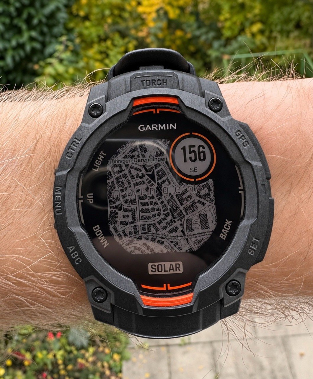
Online mode streams OpenTopoMap through Garmin Connect on a paired phone with internet access. It can show finer detail, such as building outlines, contour lines and place names where mapped, and works wherever the provider has coverage. With a GPS fix, a runner can open the map at the current position without preparing an area first. The imagery stays north up, and the position arrow shows the direction of travel.
A saved GPX route can be drawn over the streamed map, with the remaining distance in the round display. The wooded view near Bebenhausen in the hero image comes from Online mode.
On the Instinct 3 Solar and Instinct E, the Map mode menu offers three choices:
- Online only. Streams the detailed map and needs no downloaded area.
- Offline only. Uses the map already stored on the watch and works away from the phone.
- Hybrid (experimental). Tries streamed imagery when available and can fall back to a saved offline area.
What appears on the map
- Roads and paths, with different line weights and dashed minor paths.
- Rivers, streams and water boundaries where the downloaded data includes them.
- Selected names, contour lines and outdoor landmarks such as peaks and huts, where available.
Offline maps can show north or the direction of travel at the top. Pan and zoom bring junctions into view. The app shows the completed and remaining sections of a saved route and can display the distance left in the round inset.
On the Instinct 3 Solar and Instinct E, OpenMaps can also record walking, hiking and cycling activities. The wearer can pause, resume and save an activity, then sync it to Garmin Connect. The watch also offers map-name and backlight controls.
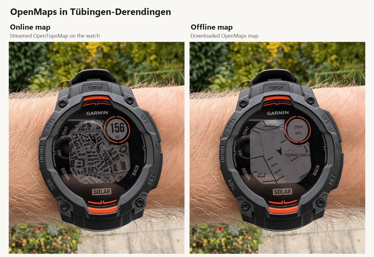
The comparison below shows the same part of Tübingen-Derendingen in both modes, each at its own zoom level. The streamed map shows individual buildings, while the downloaded map simplifies the view to roads, paths and selected names. The right panel uses a simulator capture fitted to the original wrist photo.
Supported watches and map regions
| Watch | Offline maps | Online maps | Saved routes |
|---|---|---|---|
| Instinct 3 Solar (45 mm and 50 mm) | Yes, Europe and North America | Yes | Yes |
| Instinct E (40 mm and 45 mm) | Yes, Europe and North America | Yes | Yes |
| Instinct 2, 2S and 2X | No | Yes | One GPX route |
Offline coverage follows the available datasets. Standard square downloads are 2 × 2, 4 × 4 and 8 × 8 km, and larger squares up to 24 × 24 km depend on account access. The Instinct 2 models run a smaller version of the app.
Getting a route onto the watch
- Request the link. On an Instinct 3 Solar or Instinct E, the wearer opens OpenMaps, holds MENU and selects Download maps, then Choose on phone. The link can be requested while the watch is still finding GPS.
- Send the route. The wearer opens the phone link from Garmin Connect, imports a GPX file in the OpenMaps route picker and sends it to the watch. A browser and watch code also work if the link prompt is missed.
- Open the route. Once the transfer finishes, the wearer opens the saved route, and the watch shows the downloaded corridor and track as the route progresses.
OpenMaps is one of a growing number of third-party apps filling gaps in Garmin’s own software. The monthly Connect IQ charts track the most popular of them.
Quick answers
Is the map readable on a monochrome Instinct?
The route line, position marker and junctions are distinct. Dense city views and small labels are harder to read at a glance, and zooming in helps when two paths are close together.
How much battery does OpenMaps use?
In one 20-minute hike in Offline mode, the watch used about 3 to 4% of its battery. At that rate, an hour would use roughly 9 to 12%, so about 10% is a fair rough guide. GPS settings, activity recording and backlight use change that rate, and Online mode also uses the phone connection.
What happens if the hiker leaves the downloaded corridor?
The watch keeps showing its GPS position, but the map detail ends at the edge of the saved tiles. For a route with likely detours, a separate square covering the junction or escape route gives more room to explore offline.
Map data © OpenStreetMap contributors. Streamed imagery © OpenTopoMap.
More information: OpenMaps and the Connect IQ Store.
Author: Mo, developer of OpenMaps, edited by the5krunner.
If you enjoyed reading this, here is another in the Indie Spotlight series: Indie App Spotlight: Saval runs your treadmill, turbo and rower from one app.
Last Updated on 8 November 2026 by tfk the5krunner
Small things I always use
- Garmin 90-degree charging adapter: Charges your Garmin from any USB-C cable. Essential when travelling. I use one.
- Body Glide: The blue anti-chafe stick swimmers and runners carry. I use it.
- Speedo earplugs: Fewer ear infections and no cold-water dizziness. I use them.
- Dryrobe Advance: My winter changing robe for open-water swims. I use one. A cheaper option is the AONYIYI changing robe.
- Maurten: Race fuel that stays easy on the stomach. I use them.
- Beet It Sport nitrate shots: Beetroot shots I take in the days before a race. I use them.
- Garmin charging puck: The quickest way to top up before a session. I use one.
- Injinji: Toe socks that stop rubbing, so you run more. I use them.
- Ultimate toe protectors: Stop black toenails on long runs. They work. I use them.
- Compressport R2 v2 calf sleeves: My calf sleeves of choice. I use them.
- Cellucor C4: My pre-workout before hard sessions.
- TPU tubes: Schwalbe Aerothan, Tubolito and Pirelli SmarTube. Light, tiny spares. I use all three.
- G8 insoles: Adjustable insoles that are good. I use them.
- Cycplus Cube: A 97g electric pump that gets a road tyre rideable in two minutes. I carry one. 5% off with code THE5KRUNNER.
Watches and sensors
- Polar H10: My daily driver for waking HRV.
- Polar Verity Sense: My backup arm-worn HR sensor.
- Nomad bedside charger: Charges my iPhone and Apple Watch overnight. I use it, and many of their bands.
- Train.Red: The best muscle oxygen sensor I’ve used.
- Tymewear: Accurate heart rate and reliable ventilatory zones. I use it to pace endurance rides over an hour.
- Garmin Forerunner 970: A pro-grade triathlon watch. I use this.
- Apple Watch Ultra 4: My daily smartwatch. No phone needed on rides.
- Garmin Fenix 9 Pro: I’ve just bought one.
On the bike
- Continental GP5000 for everyday riding, and Aero 111 on the front for special occasions.
- Helmets: Specialized S-Works Evade 3 for road riding, and Rudy Project Wing for TT-style races. I use both.
- Ravemen FR300: A front light that mounts under your Garmin or Wahoo. I use one.
- Ravemen FR1000: The light and the computer mount in one unit, so nothing else goes on the bars. Better than mine.
- Ravemen FR1500SE: 1,500 lumens hanging under your Garmin, for proper night rides.
- Ravemen FR1100SE: 1,100 lumens under your Garmin, and up to 46 hours on slow flash.
- Ravemen FR500: A brighter FR300 with the same mount.
- Wahoo TRACKR Radar: I use it on one bike and Varia on the other. They perform the same.
- Garmin Varia RTL515: Radar that warns you of cars from behind. I use this model.
- Wahoo ELEMNT Roam 3: The bike computer that’s easy to use. I use mine on most rides.
- Favero Assioma Pro RS2: Accurate power pedals that swap easily between bikes. I use this model.
Home and indoor training
- NPE Runn: Makes my basic treadmill smart, sending more accurate speed and distance to my watch and Zwift. I use it.
- Google Wifi: Keeps Zwift connected in my pain cave. I use it.
- Apple TV 4K: Zwift on the big screen. I use two.
- Google Nest Doorbell (wired, 2nd gen): My video doorbell, running in both Google Home and Apple Home. I use it.
Health, recovery and sleep
- FreeStyle Libre 3 Plus: Shows how my blood sugar responds to diet.
- hDrop: Measures my sweat loss in summer and indoors.
- Fourth Frontier Zone: Checks my heart under load in hard sessions.
- Kineon MOVE+: Red and infrared light for sore knees, Achilles and other joints after hard training. I use it.
- Oura Ring 5: My partner’s recovery tracker of choice.
- Eight Sleep: A cooling mattress cover my partner and I use nightly.
Reader-Powered Content

This content is not sponsored. It’s mostly me behind the labour of love, which is this site, and I appreciate everyone who supports it.
Support the site: Follow (free, fewer ads) · Subscribe (paid, ad-free) · Buy Me A Coffee
Written by real people, with AI assistance. Fact-checked and verified for originality. See the Editorial Policy. FTC: Affiliate Disclosure — some links pay commission. As an Amazon Associate, I earn from qualifying purchases.
tfk is the founder and author of the5krunner, an independent endurance sports technology publication. With 20 years of hands-on testing of GPS watches and wearables, and competing in triathlons at an international age-group level, tfk provides in-depth expert analysis of fitness technology for serious athletes and endurance sport competitors. See the gear tfk uses. ID
