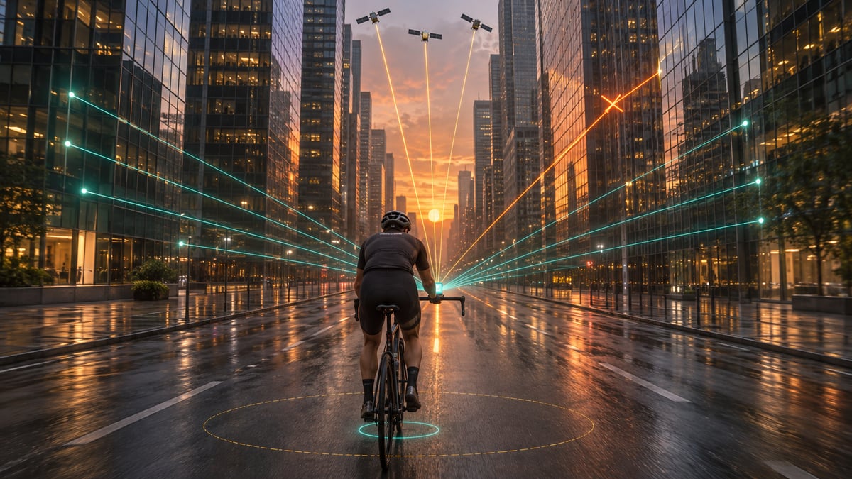
 A European research team has made satellite positioning up to 50 times more accurate between tall buildings.
Cyclists in Braunschweig have already tested it in the Naviki bike navigation app but you might have to wait quite a bit longer.
How it works
Tall buildings block some satellite signals and reflect others, so your position jumps all over the place. TU Braunschweig’s Egeniouss project fixes this with a camera. The system matches what the camera sees against Google’s 3D map of buildings, then combines that with satellite and motion data.
A building is a ground station
Your watch’s GNSS chipset already uses fixed points. SBAS ground stations sit at surveyed positions, calculate satellite errors, and your watch applies the corrections.
A tall building is also a fixed point, and radar can measure the distance to it. Distances to several buildings pin your position on the road using Google’s maps when the satellite signals are flagged as unreliable.
Bike Cameras and radar already exist. The maps exist. Google has used 3D building models since 2020 to correct phone positions in more than 3,850 cities, cutting wrong-side-of-the-street errors by about 75%. Tel Aviv University researchers have matched car radar to maps, keeping errors to about a metre across the road without satellites.
Speed Sensor
Throw in distance from a wheel-based speed sensor and fuse all the sources together, and something much more accurate than we see today could be created.
What this might one day mean for city cyclists
You get turn prompts at the right junction, tracks on the right street, and segment times that count.
Power is the problem. A camera running all ride drains a battery fast: Varia RCT715 lasts four to six hours recording video, while RearVue 820 runs 30 hours on radar alone. Radar aimed up at the higher floors, above passing traffic, would use far less, and RearVue 820 shows a bike radar can see 175 metres.
Either way, riders would need an urban positioning mode, switched on by hand or automatically when the bike computer detects tall buildings. That keeps the extra drain to the city stretches of a ride, so Edge and other bike computers keep their battery life on open roads.
Quick answers
Will my Garmin get 50x more accurate GPS in cities?
Not from this project. It was tested in a phone app using the phone’s camera. A bike computer would need a camera or radar facing the buildings, and no brand has announced one.
Why is GPS so bad between tall buildings?
Buildings block some satellite signals and reflect others. A reflected signal travels further than it should, so your device places you metres out, often on the wrong side of the street.
More on GPS accuracy in sports watches and the Garmin hub.
Last Updated on 9 November 2026 by tfk the5krunner
Small things I always use
- Garmin 90-degree charging adapter: Charges your Garmin from any USB-C cable. Essential when travelling. I use one.
- Body Glide: The blue anti-chafe stick swimmers and runners carry. I use it.
- Speedo earplugs: Fewer ear infections and no cold-water dizziness. I use them.
- Dryrobe Advance: My winter changing robe for open-water swims. I use one. A cheaper option is the AONYIYI changing robe.
- Maurten: Race fuel that stays easy on the stomach. I use them.
- Beet It Sport nitrate shots: Beetroot shots I take in the days before a race. I use them.
- Garmin charging puck: The quickest way to top up before a session. I use one.
- Injinji: Toe socks that stop rubbing, so you run more. I use them.
- Ultimate toe protectors: Stop black toenails on long runs. They work. I use them.
- Compressport R2 v2 calf sleeves: My calf sleeves of choice. I use them.
- Cellucor C4: My pre-workout before hard sessions.
- TPU tubes: Schwalbe Aerothan, Tubolito and Pirelli SmarTube. Light, tiny spares. I use all three.
- G8 insoles: Adjustable insoles that are good. I use them.
- Cycplus Cube: A 97g electric pump that gets a road tyre rideable in two minutes. I carry one. 5% off with code THE5KRUNNER.
Watches and sensors
- Polar H10: My daily driver for waking HRV.
- Polar Verity Sense: My backup arm-worn HR sensor.
- Nomad bedside charger: Charges my iPhone and Apple Watch overnight. I use it, and many of their bands.
- Train.Red: The best muscle oxygen sensor I’ve used.
- Tymewear: Accurate heart rate and reliable ventilatory zones. I use it to pace endurance rides over an hour.
- Garmin Forerunner 970: A pro-grade triathlon watch. I use this.
- Apple Watch Ultra 4: My daily smartwatch. No phone needed on rides.
- Garmin Fenix 9 Pro: I’ve just bought one.
On the bike
- Continental GP5000 for everyday riding, and Aero 111 on the front for special occasions.
- Helmets: Specialized S-Works Evade 3 for road riding, and Rudy Project Wing for TT-style races. I use both.
- Ravemen FR300: A front light that mounts under your Garmin or Wahoo. I use one.
- Ravemen FR1000: The light and the computer mount in one unit, so nothing else goes on the bars. Better than mine.
- Ravemen FR1500SE: 1,500 lumens hanging under your Garmin, for proper night rides.
- Ravemen FR1100SE: 1,100 lumens under your Garmin, and up to 46 hours on slow flash.
- Ravemen FR500: A brighter FR300 with the same mount.
- Wahoo TRACKR Radar: I use it on one bike and Varia on the other. They perform the same.
- Garmin Varia RTL515: Radar that warns you of cars from behind. I use this model.
- Wahoo ELEMNT Roam 3: The bike computer that’s easy to use. I use mine on most rides.
- Favero Assioma Pro RS2: Accurate power pedals that swap easily between bikes. I use this model.
Home and indoor training
- NPE Runn: Makes my basic treadmill smart, sending more accurate speed and distance to my watch and Zwift. I use it.
- Google Wifi: Keeps Zwift connected in my pain cave. I use it.
- Apple TV 4K: Zwift on the big screen. I use two.
- Google Nest Doorbell (wired, 2nd gen): My video doorbell, running in both Google Home and Apple Home. I use it.
Health, recovery and sleep
- FreeStyle Libre 3 Plus: Shows how my blood sugar responds to diet.
- hDrop: Measures my sweat loss in summer and indoors.
- Fourth Frontier Zone: Checks my heart under load in hard sessions.
- Kineon MOVE+: Red and infrared light for sore knees, Achilles and other joints after hard training. I use it.
- Oura Ring 5: My partner’s recovery tracker of choice.
- Eight Sleep: A cooling mattress cover my partner and I use nightly.
Reader-Powered Content

This content is not sponsored. It’s mostly me behind the labour of love, which is this site, and I appreciate everyone who supports it.
Support the site: Follow (free, fewer ads) · Subscribe (paid, ad-free) · Buy Me A Coffee
Written by real people, with AI assistance. Fact-checked and verified for originality. See the Editorial Policy. FTC: Affiliate Disclosure — some links pay commission. As an Amazon Associate, I earn from qualifying purchases.
tfk is the founder and author of the5krunner, an independent endurance sports technology publication. With 20 years of hands-on testing of GPS watches and wearables, and competing in triathlons at an international age-group level, tfk provides in-depth expert analysis of fitness technology for serious athletes and endurance sport competitors. See the gear tfk uses. ID
