Wandrer now has its own app and data field for Garmin Edge bike computers, which pull a rider’s personal map from the cloud and count newly ridden roads during the ride. That ends the old routine of generating map files, downloading them and copying them onto the Edge from a computer before heading out.
The same release adds an iPhone app, two new route planners and a new exploration score called Biggest Blob. Wandrer says every one of these features came from user requests, many of which come from its Reddit community. Wandrer already sits among the better Strava apps, scoring every new road a rider or runner covers, and I first covered it in 2020 as an alternative to Strava Local Legends.
Wandrer on Garmin Edge
The data field works live, so the count of new roads rises as the rider covers them rather than after the activity uploads. There is also an Arcade Mode, which turns collecting untravelled roads into a more interactive game on the handlebars.
Riders on Wahoo ELEMNT and Hammerhead Karoo still use Wandrer’s downloadable maps, which come with the paid Wandrer Extra membership. For anyone choosing a new unit, the bike computers hub compares the current Garmin, Wahoo and Hammerhead ranges.
iPhone app
The iOS app records bike rides and runs or walks, and shows new road progress live, both on the map and as a running total. It also shows progress in each area the athlete passes through. An Android version is on the way, and Wandrer says its routing tools will come to the app soon so that a trip to a destination can pick up as many new roads as possible.
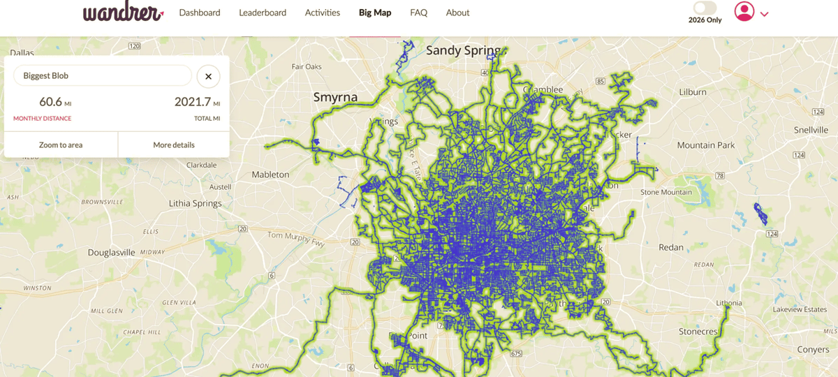
Biggest Blob
Biggest Blob is Wandrer’s version of tile hunting. Instead of rewarding a rider for completing every road in a town, it measures the largest continuous network of connected roads they have travelled. Gaps of up to 100 metres are ignored, so a mapping error or a private stretch of road does not split the network in two.
The score gives a reason to ride short, odd routes that join up isolated patches of the map. “Biking just a few miles to bridge a gap” can grow the main blob by 20 miles, according to founder Craig Durkin, and the feature has already taken off on Reddit.
Route planning
Point-to-point routing plans a trip from A to B that covers as many untravelled roads as possible. The rider sets how much extra distance they will accept, and Wandrer offers several routes to choose from.
The second tool, which Wandrer calls 100% routing or Every Road in an Area, starts with a shape drawn on the map plus a start and end point. It then builds one route that covers every road inside the shape, with options to leave out dead ends and unpaved roads, which suits clearing a whole neighbourhood in one ride or run.
Smaller changes
- Tunnels with a single entry and exit now earn map credit.
- EuroVelo cycle routes and more long-distance routes now appear on the map.
- Past activities can be searched by name.
- A year-only mode counts only activities from 2026.
- The interface is now available in Catalan.
the5krunner Thoughts on Wandrer
I’ve used Wandrer for several years, but only occasionally. The specific metric I like to see is when I’ve added some new roads that I’ve never cycled on before. I’ve cycled in and around Surrey so much that I forget some of the roads less travelled. I think I haven’t been somewhere before only to discover I have when Wandrer keeps quiet. I’ve probably cycled on most of the Surrey roads within my usual range, but even two weeks ago I bagged a new 10-mile stretch. Exciting! Well, I thought so.
I like the new BLOBS presentation on the maps and will look into it more in my own time. I’d love to see shaded areas that I’ve captured by cycling totally around them, with the regions (not roads) colour-coded by heat. There you go, developers, do that. Or someone will likely tell me it’s already been done!
Quick answers
Is Wandrer free?
Yes, a basic Wandrer account is free. It syncs your 50 most recent past activities and lets you download 10 maps for a GPS device. The paid Wandrer Extra membership adds unlimited activity syncing, including past activities, downloadable maps for Garmin Edge, Wahoo ELEMNT and Hammerhead Karoo, and monthly and yearly challenges.
Which accounts does Wandrer sync with?
Wandrer imports activities from Strava, Garmin Connect and Ride with GPS, and it can now record activities itself through its iPhone app.
Does Wandrer work on Garmin Edge?
Yes. The Wandrer app and data field for Garmin Edge loads the rider’s map from the cloud and counts new roads live during the ride, so there are no map files to copy across.
Is there a Wandrer app for Android?
Not yet. Wandrer has launched its iPhone app first and says an Android version is coming.
What is the Biggest Blob in Wandrer?
Biggest Blob is the largest continuous network of connected roads an athlete has travelled. Gaps of up to 100 metres are allowed, so small mapping errors do not break the network.
Small things I always use
- Garmin 90-degree charging adapter: Charges your Garmin with any USB-C cable. Essential when travelling. I use one.
- Body Glide: The blue anti-chafing stick swimmers and runners carry. I use it.
- Speedo earplugs: Fewer ear infections and no cold-water dizziness. I use them.
- Dryrobe Advance: My winter changing robe for open-water swims. I use one. A cheaper option is the AONYIYI changing robe.
- Maurten: Race fuel that stays easy on the stomach. I use them.
- Beet It Sport nitrate shots: Beetroot shots I take in the days before a race. I use them.
- Garmin charging puck: The quickest way to top up before a session. I use one.
- Injinji: Toe socks that stop rubbing, so you run more. I use them.
- Ultimate toe protectors: Stop black toenails on long runs. They work. I use them.
- Compressport R2 v2 calf sleeves: My calf sleeves of choice. I use them.
- Cellucor C4: My pre-workout before hard sessions.
- TPU tubes: Schwalbe Aerothan, Tubolito and Pirelli SmarTube. Light, tiny spares. I use all three.
- G8 insoles: Adjustable arches, perfect position. I use them.
- Cycplus Cube: A 97g electric pump that gets a road tyre rideable in two minutes. I carry one. 5% off with code THE5KRUNNER.
Health, recovery and sleep
- Kineon MOVE+: Red and infrared light for sore knees, Achilles and other joints after hard training. I use it.
- FreeStyle Libre 3 Plus: Shows how my blood sugar responds to diet. Occasional use.
- hDrop: Measures my sweat loss in summer and indoors. I use it.
- Fourth Frontier Zone: Checks my heart under load in hard sessions.
- Oura Ring 5: My partner’s recovery tracker of choice.
- Eight Sleep: A cooling mattress cover my partner and I use nightly.
Watches and sensors
- Polar H10: My daily driver for waking HRV.
- Polar Verity Sense: My backup arm-worn HR sensor.
- Nomad bedside charger: Charges my iPhone and Apple Watch overnight. I use it, and many of their bands.
- Train.Red: The best muscle oxygen sensor I’ve used. Occasional use.
- Tymewear: Accurate heart rate and reliable ventilatory zones. I use it to pace endurance rides over an hour.
- Garmin Forerunner 970: A pro-grade triathlon watch. I use this.
- Apple Watch Ultra 4: My daily smartwatch. No phone needed on rides.
On the bike
- Continental GP5000 for everyday riding, and Aero 111 on the front for special occasions. I use both.
- Helmets: Specialized S-Works Evade 3 for road riding, and Rudy Project Wing for TT-style races. I use both.
- Ravemen FR300: A front light that mounts under your Garmin or Wahoo. I use one.
- Ravemen FR1000: The light and the computer mount in one unit, so nothing else goes on the bars. Better than mine.
- Ravemen FR1500SE: 1,500 lumens hanging under your Garmin, for proper night rides.
- Ravemen FR1100SE: 1,100 lumens under your Garmin, and up to 46 hours on slow flash.
- Ravemen FR500: A brighter FR300 with the same mount.
- Wahoo TRACKR Radar: I use it on one bike and Varia on the other. They perform the same.
- Garmin Varia RTL515: Radar that warns you of cars from behind. I use this model.
- Wahoo ELEMNT Roam 3: The bike computer that’s easy to use. I use mine on most rides.
- Favero Assioma Pro RS2: Accurate power pedals that swap easily between bikes. I use this model.
Home and indoor training
- NPE Runn: Makes my basic treadmill smart, sending more accurate speed and distance to my watch and Zwift. I use it.
- Google Wifi: Keeps Zwift connected in my pain cave. I use it.
- Apple TV 4K: Zwift on the big screen. I use two.
- Google Nest Doorbell (wired, 2nd gen): My video doorbell, running in both Google Home and Apple Home via Starling. I use it.
Reader-Powered Content

This content is not sponsored. It’s mostly me behind the labour of love, which is this site, and I appreciate everyone who supports it.
Support the site: Follow (free, fewer ads) · Subscribe (paid, ad-free) · Buy Me A Coffee
Written by real people, with AI assistance. Fact-checked and verified for originality. See the Editorial Policy. FTC: Affiliate Disclosure — some links pay commission. As an Amazon Associate, I earn from qualifying purchases.
tfk is the founder and author of the5krunner, an independent endurance sports technology publication. With 20 years of hands-on testing of GPS watches and wearables, and competing in triathlons at an international age-group level, tfk provides in-depth expert analysis of fitness technology for serious athletes and endurance sport competitors. See the gear tfk uses. ID
