Ride with GPS 3D Maps: What It Does and How It Compares
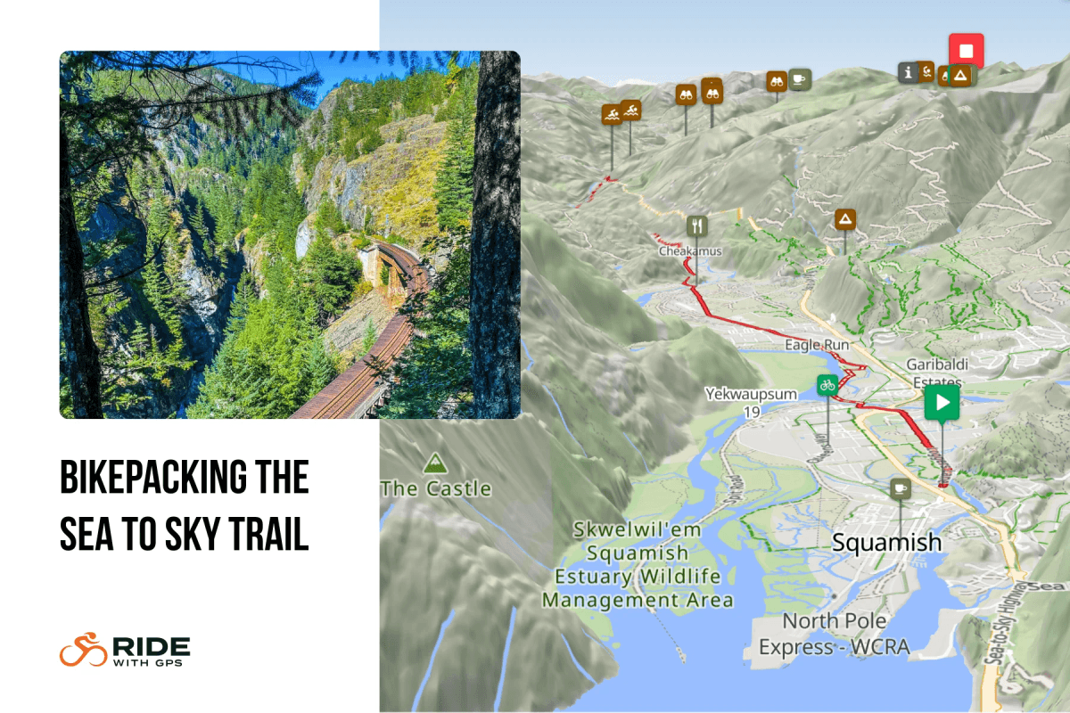
Ride with GPS added 3D map views across its website and mobile app this week, letting riders tilt, rotate and pan any route or activity to see the terrain instead of reading it off a flat contour line. The feature works during route planning, live navigation and activity recording, on both platforms.
Ride with GPS’s Basic plan, a paid tier below Premium, gets 3D maps everywhere except the web-based Route Planner – according to Ride with GPS’s own support documentation. That doesn’t say whether Starter, the platform’s actual free tier, gets 3D maps at all, I assume not.
- Garmin added 3D maps to Connect in November 2025, restricted entirely to Connect+ subscribers at $6.99 a month or $69.99 a year. Garmin’s own announcement limits the feature to logged activities, custom courses and Garmin Trails. There’s no live navigation use. Garmin Explore, a separate app aimed at hikers and overlanders, picked up its own 3D view in August 2026, again for planning courses and reviewing activities rather than navigating in real time.
- Komoot has offered 3D maps since 2022, priced at $59.99 a year as part of Komoot Premium. It remains locked behind that subscription and, per Komoot’s own support documentation, works only on the desktop website. There’s no app version and no navigation mode.
Ride with GPS is the only one of the three that puts 3D terrain into an active ride: tilt into 3D mid-navigation on the phone to spot a climb before you reach it. Riders using the web planner to build a route in advance still need Premium, the same gate Komoot has used since 2022.
| Platform | Cost for 3D maps | Where it works | Live navigation |
|---|---|---|---|
| Garmin Connect | Connect+, $6.99/month or $69.99/year | Activities, courses and trails only | No |
| Komoot | Premium, $59.99/year | Desktop website only | No |
| Ride with GPS | Basic plan ($60/year),
Premium ($79.99/year) includes web planner |
Web and mobile app | Yes |
One limit applies across the board on Ride with GPS: 3D maps only work on OSM-based map types (RWGPS Cycle, OSM, ESRI, USGS). Riders using Google-based map layers don’t get the option, a restriction Ride with GPS attributes to Google rather than its own platform.
For riders already choosing between the three, Garmin and Komoot both gate 3D maps behind their top paid tier. Ride with GPS unlocks most of it one tier down, on Basic, and reserves only the web planner for Premium.
Quick answers
Is Ride with GPS 3D Maps free?
Not on every tier. It’s included on the paid Basic plan everywhere except the web-based Route Planner, which needs Premium. Ride with GPS’s own documentation doesn’t say whether the free Starter tier includes it.
Does Ride with GPS 3D Maps work with every map type?
No. It works with OSM-based maps only, including RWGPS Cycle, OSM, ESRI and USGS. It does not work with Google-based map types, a limitation Ride with GPS attributes to Google.
How does this compare to Garmin and Komoot's 3D maps?
Garmin’s version, added to Connect in November 2025, requires a Connect+ subscription and only covers logged activities, courses and trails, not live navigation. Komoot has offered 3D maps since 2022, but only on its website, gated behind Premium, with no mobile app or navigation support.
Last Updated on 17 September 2026 by the5krunner
My favourite kit and nutrition
- Garmin Fenix 9 Pro — I’ve just bought one.
- Injinji – Runners protect your toes. Avoid discomfort and minor injury. Run more. Run faster. I use them.
- Garmin 90-degree charging adapter — A small keyring adapter you can use anywhere. Essential when away. I use one.
- Garmin charging puck — the fastest and most reliable way to top up your Garmin before a session. I use one.
- Ravemen FR300 — Front light that mounts directly under your Garmin or Wahoo head unit. Keeps your bars clean and your beam pointed where it matters. I use one.
- Body Glide – The blue anti-chafe stick that all swimmers and many runners use. I use it.
- Maurten — The race nutrition trusted by elite athletes. Gels and drink mixes engineered to be easy on the stomach. I use them.
- Garmin Varia RTL515 — A radar rear light that alerts you to vehicles approaching from behind. Pairs with your Edge or Wahoo. I use this model.
- Favero Assioma Pro RS2 — The power-meter pedals most serious cyclists choose. Accurate, easy to move between bikes. I use this model.
- Garmin Forerunner 970 — A serious choice for a pro-grade triathlon watch. I use this.
- Polar H10 — My daily driver for accurate, waking HRV readings.
- Wahoo ELEMNT Roam 3 — The bike computer that has the feature Garmin lacks: usability. I use mine on most rides.
Reader-Powered Content

This content is not sponsored. It’s mostly me behind the labour of love, which is this site, and I appreciate everyone who supports it.
Support the site: Follow (free, fewer ads) · Subscribe (paid, ad-free) · Buy Me A Coffee ❤️
All articles are written by real people, fact-checked, and verified for originality. See the Editorial Policy. FTC: Affiliate Disclosure — some links pay commission. As an Amazon Associate, I earn from qualifying purchases.
tfk is the founder and author of the5krunner, an independent endurance sports technology publication. With 20 years of hands-on testing of GPS watches and wearables, and competing in triathlons at an international age-group level, tfk provides in-depth expert analysis of fitness technology for serious athletes and endurance sport competitors. ID

Definitely not on the RWGPS Starter edition… lots of upgrade prompts.
Comparisons table could have a lot more route comparable… a biggie Strava certainly has 3D mode for subscriber viewing and (poor) course creation.
GPX.studio has great course planning but low integration (gotta love a raw GPX file) and 3D exaggeration is set quite low.