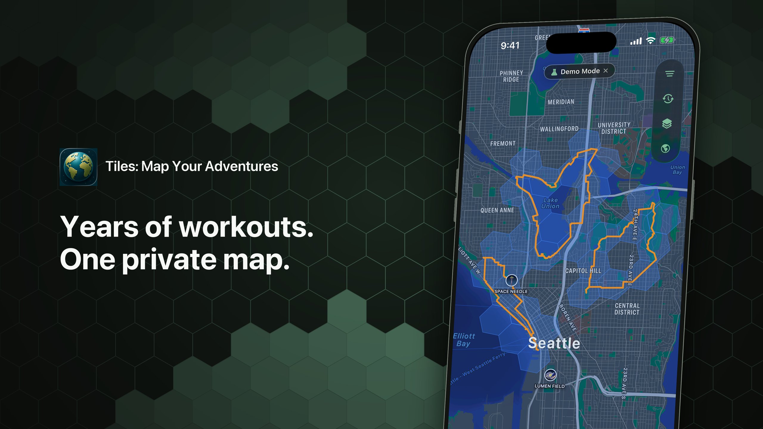
Every walk, run, hike or bike ride recorded with an Apple Watch or iPhone is already saved somewhere in Apple Health. The routes exist, but they usually stay hidden inside individual workouts. Tiles is a new iPhone app designed to bring those routes together, creating a personal, private map that grows every time the user goes for a walk, run, hike or bike ride.
The idea is straightforward: Tiles reads workout routes from Apple Health and lays them onto one private map. Over time, the map covers more area, showing where the user has been active.
Apple Health workouts, GPX imports and a private map
TL;DR: Tiles reads workout routes from Apple Health locally on the iPhone and can also import GPX, FIT and CSV files from older activities on Garmin, Strava, Wahoo or other platforms.
Simply opening Apple Health does not show a person their history in a spatial way. Tiles pulls the location data from stored workouts and displays a personal map covered in hexagonal tiles. Each tile shows an area the user has moved through.
Instead of scrolling through individual workouts, users can zoom out on their entire history of movement.
Beyond Apple Health data, Tiles imports GPX, FIT and CSV files. This allows users to include older activities recorded on Garmin, Strava, Wahoo or other platforms alongside those saved in Apple Health.
Not everyone has always logged workouts through an Apple Watch. Older FIT and GPX files remain valid records of a route on foot, on a bike or in the water, and CSV support is useful for exports from platforms that do not use GPX or FIT.
The map that fills in over time
The map builds itself as workouts are added.

For newer devices, opening the app is enough. Tiles reads routes from workouts already stored in Apple Health, no imports needed.
For iPhone users with older activity data on other services, GPX, FIT and CSV files can be added to complete the picture.
The map does not require online services beyond the Apple Health data already on the device. That means Tiles works even without a mobile connection, in the background, once the initial data is in place.
Private by design
By default, Tiles reads Apple Health workouts locally. Nothing is uploaded, nothing is shared, and there is no online account. The map builds itself on the device.
An optional iCloud sync keeps a personal map consistent across the user’s own devices, using end-to-end encryption. Data still stays private to the user; iCloud is used purely as a personal sync mechanism.
How Tiles fits with other tools
Tiles works alongside training tools like Strava and TrainingPeaks as a private, personal atlas.
Some users prefer to explore quietly, without competition, followers or leaderboards. Tiles is designed for that kind of use, where the goal is to notice patterns in one’s own movement over time.
For explorers, quiet users and route finders
Tiles is designed for people who like to look at movement patterns. Runners might notice which neighborhoods they’ve circled dozens of times, cyclists can rediscover early rides, and hikers can spot small parts of a trail network they have not yet walked.
For hikers and runners moving into unfamiliar terrain, the hexagonal grid can also suggest small navigational decisions. Filled tiles show where the user has already been. Empty tiles show where interesting variation might be waiting on a walking or running route.
Current features and roadmap
Tiles focuses on the past, and the future direction that past suggests. The current version already supports iPhone with iPad and Apple Watch companion apps, background Apple Health sync when new workouts appear, and the visual grid of hexagonal tiles for hikers, runners, cyclists and walkers.
The developer is now expanding the imported file formats. Support for a wider range of workout types is also on the way, so activities such as swimming, skiing and rowing can be included in the same map view alongside walks and runs.
None of these additions changes the core idea: Tiles is designed to belong to the user. Data stays on the device, is private by default, and is meant to be explored personally, quietly and without a leaderboard.
That principle stays in place regardless of how many files, activity types or map views the app supports over time.
Summary
Tiles takes activity data that already lives inside Apple Health, adds GPX, FIT and CSV files where useful, and turns them into a private map that fills in as users move. It is designed for anyone who wants to see their movement history over time, whether the goal is fitness, exploration or the quiet pleasure of watching a personal map fill in. Tiles is available on the App Store.
Quick answers
Which activities does Tiles cover?
Tiles reads walks, runs, hikes and bike rides recorded through Apple Watch or iPhone, and imports older activity files in GPX, FIT and CSV formats. Support for additional activity types including swimming, skiing and rowing is planned.
Does Tiles work without an internet connection?
Yes. Tiles reads Apple Health workouts and imported files locally on the device. No online account is required, and nothing is uploaded. Optional iCloud sync uses end-to-end encryption if the user wants their map to appear across multiple Apple devices.
How does Tiles compare with Strava?
Tiles is a private personal map that runs on the device rather than a social training network. There are no followers, no leaderboards and no shared feed. It works alongside training tools like Strava rather than replacing them.
Related reading on the5krunner
- Vitara: Apple Health Tells You What Happened, Vitara Shows What Changed: closest sibling, another privacy-first iPhone app running on Apple Health data locally on the device.
- Tooboo: Standalone Offline Outdoor Navigation on Apple Watch Ultra: another indie outdoor app for hikers and trail runners, built for offline operation.
- Cinder: An Apple Watch Recovery App That Shows Its Working: another privacy-first Apple ecosystem indie app, reading Apple Health data locally with no data collection.
Author: Erik Handeland, developer of Tiles, edited by the5krunner.
The previous Indie Spotlight covered Back My Run.
Last Updated on 27 August 2026 by tfk the5krunner
Small things I always use
- Garmin 90-degree charging adapter: Charges your Garmin from any USB-C cable. Essential when travelling. I use one.
- Body Glide: The blue anti-chafe stick swimmers and runners carry. I use it.
- Speedo earplugs: Fewer ear infections and no cold-water dizziness. I use them.
- Dryrobe Advance: My winter changing robe for open-water swims. I use one. A cheaper option is the AONYIYI changing robe.
- Maurten: Race fuel that stays easy on the stomach. I use them.
- Garmin charging puck: The quickest way to top up before a session. I use one.
- Injinji: Toe socks that stop rubbing, so you run more. I use them.
- Ultimate toe protectors: Stop black toenails on long runs. They work. I use them.
- Compressport R2 v2 calf sleeves: My calf sleeves of choice. I use them.
- Cellucor C4: My pre-workout before hard sessions.
- TPU tubes: Schwalbe Aerothan, Tubolito and Pirelli SmarTube. Light, tiny spares. I use all three.
- G8 insoles: Adjustable insoles that are good. I use them.
- Cycplus Cube: A 97g electric pump that gets a road tyre rideable in two minutes. I carry one. 5% off with code THE5KRUNNER.
Watches and sensors
- Polar H10: My daily driver for waking HRV.
- Polar Verity Sense: My backup arm-worn HR sensor.
- Nomad bedside charger: Charges my iPhone and Apple Watch overnight. I use it, and many of their bands.
- Train.Red: The best muscle oxygen sensor I’ve used.
- Tymewear: Accurate heart rate and reliable ventilatory zones. I use it to pace endurance rides over an hour.
- Garmin Forerunner 970: A pro-grade triathlon watch. I use this.
- Apple Watch Ultra 4: My daily smartwatch. No phone needed on rides.
- Garmin Fenix 9 Pro: I’ve just bought one.
On the bike
- Continental GP5000 for everyday riding, and Aero 111 on the front for special occasions.
- Helmets: Specialized S-Works Evade 3 for road riding, and Rudy Project Wing for TT-style races. I use both.
- Ravemen FR300: A front light that mounts under your Garmin or Wahoo. I use one.
- Wahoo TRACKR Radar: I use it on one bike and Varia on the other. They perform the same.
- Garmin Varia RTL515: Radar that warns you of cars from behind. I use this model.
- Wahoo ELEMNT Roam 3: The bike computer that’s easy to use. I use mine on most rides.
- Favero Assioma Pro RS2: Accurate power pedals that swap easily between bikes. I use this model.
Home and indoor training
- NPE Runn: Makes my basic treadmill smart, sending more accurate speed and distance to my watch and Zwift. I use it.
- Google Wifi: Keeps Zwift connected in my pain cave. I use it.
- Apple TV 4K: Zwift on the big screen. I use two.
- Google Nest Doorbell (wired, 2nd gen): My video doorbell, running in both Google Home and Apple Home. I use it.
Health, recovery and sleep
- FreeStyle Libre 3 Plus: Shows how my blood sugar responds to diet.
- hDrop: Measures my sweat loss in summer and indoors.
- Fourth Frontier Zone: Checks my heart under load in hard sessions.
- Oura Ring 5: My partner’s recovery tracker of choice.
- Kineon MOVE+: Red light therapy for niggles. It works.
- Eight Sleep: A cooling mattress cover my partner and I use nightly.
Reader-Powered Content

This content is not sponsored. It’s mostly me behind the labour of love, which is this site, and I appreciate everyone who supports it.
Support the site: Follow (free, fewer ads) · Subscribe (paid, ad-free) · Buy Me A Coffee ❤️
Written by real people, with AI assistance. Fact-checked and verified for originality. See the Editorial Policy. FTC: Affiliate Disclosure — some links pay commission. As an Amazon Associate, I earn from qualifying purchases.
tfk is the founder and author of the5krunner, an independent endurance sports technology publication. With 20 years of hands-on testing of GPS watches and wearables, and competing in triathlons at an international age-group level, tfk provides in-depth expert analysis of fitness technology for serious athletes and endurance sport competitors. ID
