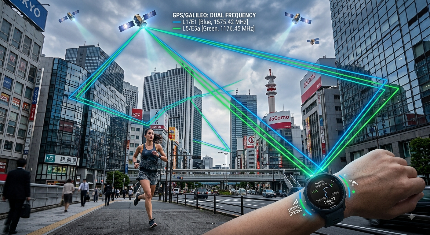
The latest Pixel Watch 5 records a run much like any other GPS watch. The clever bit happens afterwards.
Google says the watch compresses the raw satellite data and sends it away for processing instead of doing all the heavy work on your wrist. In part, that helps save some battery juice. What is sent back is a cleaned version of the route you actually ran.
The system compares your track with Google’s 3D map models. It then works out which satellite signals were likely to have reached you directly and which may have bounced off buildings first. Google also uses ground reference stations to help mitigate errors caused by atmospheric effects. The brand says it tested the system over more than 4,000 miles.
Google claims the result is twice as accurate as the Pixel Watch 4 in built-up environments, and better than an Apple Watch Ultra 3 and Garmin Fenix 8 Pro. Those are Google’s own test results, from testing carried out in July on pre-production watches and runs lasting three hours or less.
But none of that helps you until after you have stopped running. Is there any point in this?
What you actually look at when you run
Current pace. Lap pace. How far you have left in the interval. Those are the numbers that appear on your wrist while you run, and they are what you use to decide whether to push harder or ease off. Or, at least I do.
The new correction cannot and does not change what you saw at the time.
That is not specifically meant as a criticism of the technology, which is a clever concept. It is simply the real-world limitation of post-processing.
What changes once you have finished?
The two obvious things are the shape of the line on the map and, potentially, the final distance recorded by the app. Google says the corrected route may differ from the one you saw during the run.
Whether that matters depends on what you wanted from the run. If you were trying to hold a particular pace, the correction came too late to help. If you wanted an accurate record of where you went, that is exactly what the correction delivers.
Why can’t the watch fix this by itself?
Dual-frequency GPS already helps with reflected satellite signals, and it can make a big difference. Using two frequencies gives the receiver more information to work with, particularly when the sky is clear.
But it cannot solve every problem, and the reason is worth understanding.
A reflected signal takes a longer route to your wrist than a direct one, and that extra distance (time) can be used to flag a bad signal. The catch is how much extra distance the watch needs to spot the difference. On the newer L5 signal, a reflection has to have travelled about 29 metres farther than the direct signal before the watch can identify it and discard it. On the older L1 signal, that figure is around 290 metres.
In a normal downtown street setting, the building bouncing your signal is perhaps fifteen or twenty metres away, so the reflection arrives well inside that 29-metre threshold. Your watch cannot separate it from the real thing, and uses it anyway. Chipset makers work hard on this: u-blox explains its own multipath mitigation by leaning more heavily on L5 when it detects a reflective environment.
It gets worse when the building blocks the direct signal completely, because then there is no clean signal left to compare against. Reflections are all the watch has to work with.
That is why even watches with very good dual-frequency GPS still produce ugly tracks in cities. The 10-mile test course at this site has exhibited the same dual-frequency failure for several years, with tracks pushed sideways by adjacent buildings.
Google’s approach sidesteps the problem. Instead of trying to identify a bad signal from the satellite data alone, it uses the 3D map once the data has synced. If the model shows a building blocking the path to a satellite, that signal is eliminated.
Which is worth remembering next time a watch is sold to you on dual frequency. Michael George’s technical series on GNSS covers the signal mechanics properly if you want the detail, and his chipset database records which receiver sits in which watch.
Cars have done something similar for decades
Sat-nav systems have been making GPS tracks look cleaner for decades by assuming that a car is on a road. If all you want is a neat line, snapping the GPS position to a known road is a simple solution.
But runners are not cars.
You run on tracks. You cut across parks. You cross a road diagonally. You take a footpath. You double back to pick up a dropped gel. You might even run down the middle of a road that has been closed for a race.
Snapping the track to the nearest road or path can make the post-workout map look tidy, but it can also change where you actually ran.
Google’s method is more complicated, but it has an important advantage: it does not require assuming that you were on a particular road. That makes more sense for running, especially away from built-up areas where there may not be a useful road or path to snap to.
I suspect there is still a better answer that can use a snap-to method when confidence limits that you are on the normal path are exceeded. Perhaps even a snap-to method that can use Strava or Garmin heatmaps of where we actually usually run.
What happens when the model is wrong?
The system depends on Google having a good picture of the environment around you.
What happens when that picture is wrong or incomplete? Scaffolding, cranes, temporary structures and construction work can all affect satellite signals. A building may also have changed since the data the system uses was collected.
Google has not explained in detail how the correction behaves when the real world and its 3D model disagree.
When is it good?
There are some clear positives to Google’s method, e.g. when
- Measuring a course;
- Checking a race distance; or
- Settling an argument about an ultra record.
Basically, anything where the GPS track needs to be some form of athletic evidence. For those kinds of uses, the timing is irrelevant.
For most people…it’s simply a prettier picture for your Strava/Runna feed
Quick answers
Does the Pixel Watch 5 GPS correction improve pace during a run?
No. The system works on Google’s servers once your workout uploads, so every number displayed on the watch mid-run comes from the watch alone and stays exactly as you saw it.
Can the corrected track change my recorded distance?
Yes. Because the route is redrawn, the total distance stored in the app may differ slightly from the figure your watch showed when you finished.
Is Google snapping my run to the nearest road?
No. Road snapping assumes you were on a mapped route and moves your track onto it. Google instead uses building and terrain models to judge which satellite signals were trustworthy, so a park crossing or a lap of the track stays where you ran it.
Why can't dual-frequency GPS fix this on its own?
A receiver identifies a reflected signal by the extra distance it travelled, and there is a minimum below which the difference is too small to detect. That floor sits at roughly 29 metres on L5 and 290 metres on L1. Buildings lining a street sit far closer than either figure.
Will the GPS correction come to the Pixel Watch 4?
Google has confirmed the feature for the Pixel Watch 5 only at this stage, while stopping short of ruling out earlier models.
More: Pixel Watch 5 full specifications | Pixel Watch 4 specifications | GPS accuracy in sports watches | Google Fitbit and Wear OS
Source: How we built the new GPS on Pixel Watch 5, Google.

Explore the full resource library
This site covers endurance sport technology across a range of dedicated reference sections. Each one collects the most relevant articles, tests, and analysis on its topic in one place.
Buyer guides
- Best sports watch — tested recommendations by sport and athlete type: triathlon, running, marathon, cycling, hiking, and women
- Best Garmin watch — Forerunner versus Fenix by series, sport, and budget
- Best wearables — recovery trackers, heart rate monitors, running power meters, and female athlete tech
- Best cycling products — computers, smart trainers, power meters, and cycling heart rate monitors
Brand and product guides
- Amazfit — the full Amazfit range from Balance to Cheetah to T-Rex, accuracy tests, HYROX partnership, and Zepp Health analysis
- Apple Watch — athlete-first coverage of Apple Watch across running, cycling, and triathlon
- COROS — watches, features, and firmware across the full COROS range
- Garmin — the company, the platform and the full range, and the starting point for choosing across every Garmin product line
- Garmin Edge — bike computers from entry-level navigation to flagship endurance and mountain biking
- Garmin Fenix — every model, feature, and firmware development for Garmin's flagship outdoor watch
- Garmin Fenix 8 Series — which variant to buy, upgrade advice, accuracy data, and the full Fenix 8 review and firmware coverage
- Garmin Forerunner — the full Forerunner line covered from entry level to triathlon flagship
- Garmin Instinct — rugged GPS watches for endurance and adventure athletes
- Garmin Features Explained — how Garmin's metrics work, from Training Load and Body Battery to Race Predictor and HRV Status
- Google Fitbit — Fitbit Air, Google Health, Pixel Watch and the Wear OS platform
- Polar — watches, sensors, Polar Flow and training science across the full Polar range
- Suunto — Race, Vertical, Run and the SuuntoPlus ecosystem
- Strava — features, privacy, segments, and how Strava fits into a serious training setup
- Wahoo — KICKR trainers, ELEMNT bike computers, and the Wahoo ecosystem
- WHOOP — strain, recovery, sleep and the full WHOOP ecosystem
Specifications database
- Full Specifications Database — detailed spec sheets, battery life, sensor lists and generation-on-generation comparisons for current Garmin, COROS, Amazfit, Samsung, Google Fitbit, Huawei, Polar, Suunto, Wahoo and Apple Watch models
Glossary
- Sports Technology Glossary — non-branded terminology across running, cycling, swimming, triathlon, hiking, strength training, HYROX, sensors, ecosystems, and brands
Sport and topic guides
- Running Watches — how to choose by discipline: road racing, trail, track, beginner, and multisport
- Triathlon and Multisport Technology — watches, sensors, and race-day tools for swimmers, cyclists, and runners
- HYROX — training science, race analysis, and technology for the functional fitness race format
- parkrun — technology, training, and performance for the weekly 5K
- Hiking Technology — navigation, safety, and trail tech for walkers and hikers
- Heart Rate Monitoring — optical sensors, chest straps, accuracy comparisons, and how to set training zones
- GPS Accuracy — how satellite systems perform across brands, terrains, and conditions
- Sports Watch Battery Life — battery claims, real-world tests, and how to manage battery life across Garmin, Apple, Amazfit and Coros
- Recovery Trackers — WHOOP, Oura, and the science of readiness scoring
- Female Athlete Tech — wearables, physiology, and performance for female endurance athletes, covering cycle-synced training, RED-S, HR accuracy, and VO2max
- Sports Science — peer-reviewed research on HRV, VO2max, lactate threshold, running power, wearable accuracy, and supplementation
- Testing Methodology — how this site tests GPS accuracy, heart rate, battery life, and other performance claims
Content series
- Release Radar — confirmed launches, leaks, and rumours across Garmin, Apple, COROS, Polar, Suunto, and Wahoo
- Deep Dive Feature Files — weekly firmware feature updates across all brands (bug fixes excluded)
- Fix Files — weekly firmware bug fix tracking across all brands
Last Updated on 21 August 2026 by the5krunner
My favourite kit and nutrition
- Garmin Fenix 9 Pro — I’ve just bought one.
- Injinji – Runners protect your toes. Avoid discomfort and minor injury. Run more. Run faster. I use them.
- Garmin 90-degree charging adapter — A small keyring adapter you can use anywhere. Essential when away. I use one.
- Garmin charging puck — the fastest and most reliable way to top up your Garmin before a session. I use one.
- Ravemen FR300 — Front light that mounts directly under your Garmin or Wahoo head unit. Keeps your bars clean and your beam pointed where it matters. I use one.
- Body Glide – The blue anti-chafe stick that all swimmers and many runners use. I use it.
- Maurten — The race nutrition trusted by elite athletes. Gels and drink mixes engineered to be easy on the stomach. I use them.
- Garmin Varia RTL515 — A radar rear light that alerts you to vehicles approaching from behind. Pairs with your Edge or Wahoo. I use this model.
- Favero Assioma Pro RS2 — The power-meter pedals most serious cyclists choose. Accurate, easy to move between bikes. I use this model.
- Garmin Forerunner 970 — A serious choice for a pro-grade triathlon watch. I use this.
- Polar H10 — My daily driver for accurate, waking HRV readings.
- Wahoo ELEMNT Roam 3 — The bike computer that has the feature Garmin lacks: usability. I use mine on most rides.
Reader-Powered Content

This content is not sponsored. It’s mostly me behind the labour of love, which is this site, and I appreciate everyone who supports it.
Support the site: Follow (free, fewer ads) · Subscribe (paid, ad-free) · Buy Me A Coffee ❤️
All articles are written by real people, fact-checked, and verified for originality. See the Editorial Policy. FTC: Affiliate Disclosure — some links pay commission. As an Amazon Associate, I earn from qualifying purchases.
tfk is the founder and author of the5krunner, an independent endurance sports technology publication. With 20 years of hands-on testing of GPS watches and wearables, and competing in triathlons at an international age-group level, tfk provides in-depth expert analysis of fitness technology for serious athletes and endurance sport competitors. ID

Interesting that it will change the distance or other metrics. That is different than Garmin’s post processing which just cleans up the track but doesn’t touch any other metrics like distance. Does Apple do any post processing like this, or is their “snap to” logic real time on device?
Ray’s review indicated distance doesn’t get updated from post processing. That actually makes more sense since as he says, distance on all these devices isn’t just coming from the raw GPS data
the brand makes those claims.
you’ll have to ask the other influencers if they’ve been paid or had freebies from the company. I haven’t
As far as I know, the GPS data is refined in the cloud *after* the activity is finished. That has nothing to do with the new watch; they could do the same thing with a 10-year-old GPS watch. It’s just marketing. Besides, the watch still lacks basic features, and I think it’s absolutely hideous! I wouldn’t take one even if it were free. No way!
If you see the raw unprocessed GPS data in videos from DCR, DesFit or Chase the Summit…it’s really bad…all over the place. At the end of the day, the biggest advantage you have as an athlete is, you have a pretty and straight line in your post activity report. And I agree, the watch looks really bad especially with the plastic-y looking strap. But at least, the technology behind it is interesting from a geeky point of view.
yes i saw that too. it looked quite bad in comparison – live distance and live pace would be all over the place. might as well use snap-to for the image of a city run. There was the feature that suunto did where you followed a city course and it updated your position on the course as it progressed to keep the numbers better aligned (again, gimmick)
tho when you get the watch it actually REALLY grows on you looks-wise. i like it.
Why is your headline: Pixel Watch 5 best ever GPS
the GPS itself is just OK in comparison to what other devices are doing…..why are all the influencers/youtubers all calling it the best GPS or most accurate. why is everyone trying to mislead. for clickbait or they are being paid to say such nonsense?