TouchTrails: flexible GPX route planning with standalone Apple Watch navigation
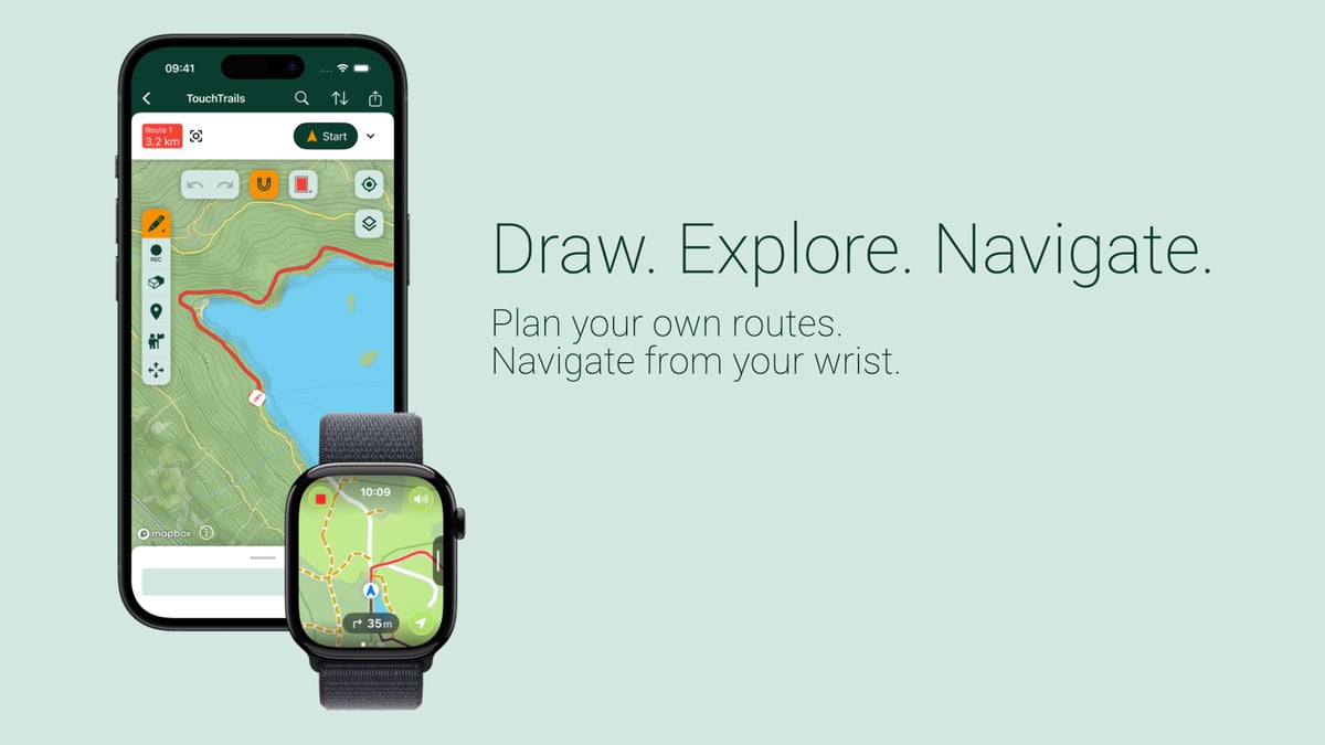
Finding the right route for a trail run is rarely straightforward. Sometimes you want to build one from scratch to a target distance or elevation. More often, you have a GPX file that is close to what you need but not quite right: a detour would improve it, a steep section should be removed, or two separate routes should be merged.
Most outdoor apps handle one of those workflows well. Few handle both. TouchTrails, built by Austrian independent developer Wolfgang Knecht, is designed around the premise that route planning should adapt to the run, not the other way around. The app covers drawing from scratch, GPX import, multi-file merging, and standalone navigation on Apple Watch without an iPhone. It is available on Android and iPhone, with the Apple Watch component as a separate companion app.
How the planning workflow works
A typical session starts with either a blank map or an imported GPX file. Drawing works by tracing directly on the map with a finger; an optional Snap to Road mode keeps the line on known paths, though going fully off-road is also supported. Distance and elevation gain update in real time as you draw, and the elevation profile is visible throughout planning.
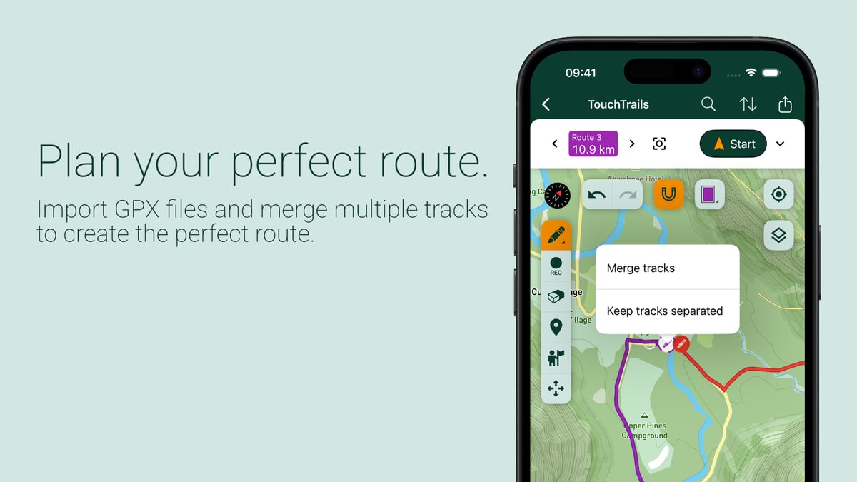
Where TouchTrails differs from most route planners is in how it handles existing files. GPX routes imported from other apps or websites can be edited rather than treated as fixed. Sections can be removed with an eraser tool, detours added, or two separate GPX files merged into a single route. The app’s own worked example illustrates the case clearly: a 10.9 km scenic route and a 5.6 km forest loop imported separately, merged, then trimmed to 12.8 km with 380 m of elevation gain.
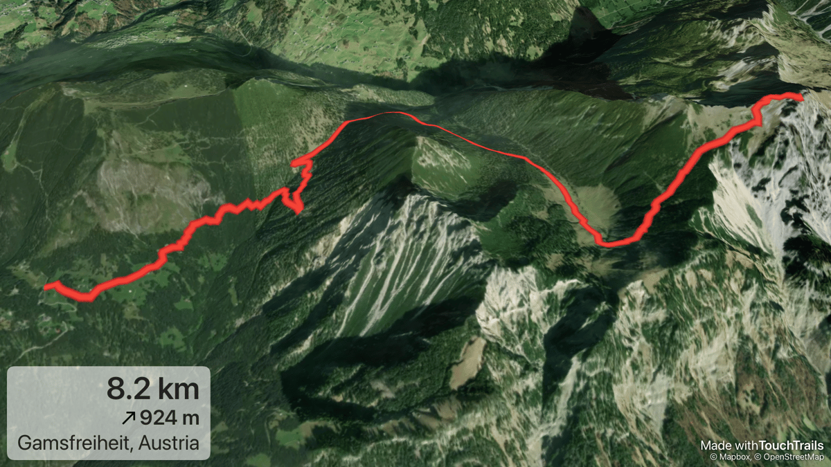
Finished routes can be exported as GPX files for use in other apps and devices. They can also be shared as 3D flyover videos and images, which give a terrain preview before heading out.
Standalone Apple Watch navigation
Once a route is ready, it can be sent to the Apple Watch. The transfer includes the route, offline maps, and navigation data. The watch then navigates independently: no iPhone connection is required during the activity.
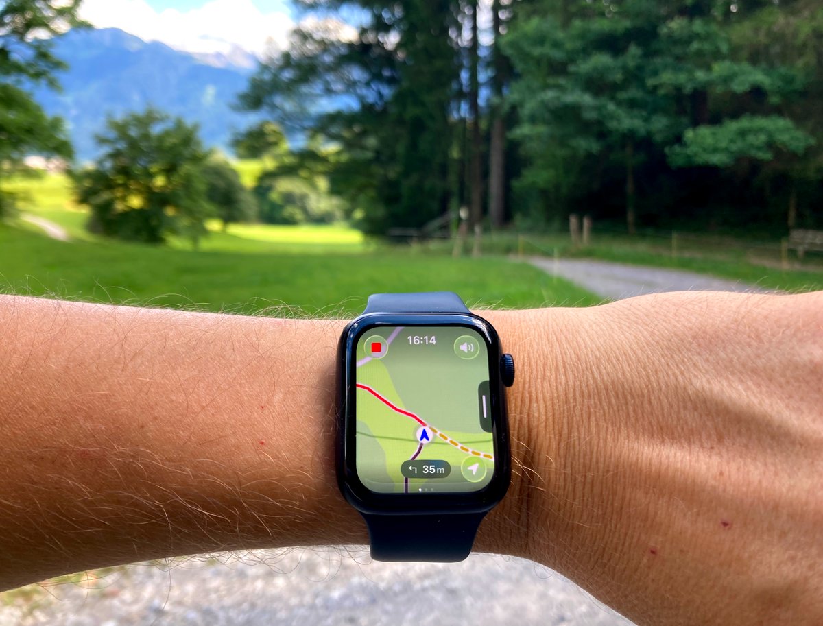
During navigation, the watch shows position on the offline map alongside the planned route, upcoming turn-by-turn instructions, remaining distance, elevation gain, and an elevation profile of what lies ahead. Haptic alerts fire at turns and when you leave the route. Because maps and routing data are stored locally on the device, there is no dependency on a mobile signal or the phone’s GPS.
Standalone Apple Watch navigation remains a niche capability. Most running apps that include a Watch component require the phone to be present for full navigation; the Watch functions as a display rather than an independent navigator. Apps such as Komoot and WorkOutDoors offer offline map support on Apple Watch, so TouchTrails is entering an established but small field rather than creating one.
Free and premium tiers
TouchTrails is free to download on both platforms. Route planning, GPX import and editing, and 3D image and video generation are all available free of charge. The premium tier adds GPX export, offline maps, turn-by-turn navigation on iPhone, and standalone offline navigation on Apple Watch. No account or login is required to use the app at either tier.
Platform and feature summary
| Category | Feature | Free | Premium |
|---|---|---|---|
| Planning | Draw routes on the map | Yes | Yes |
| Planning | Snap to Road routing | Yes (3/day) | Yes |
| Planning | GPX import and editing | Yes | Yes |
| Planning | Merge multiple GPX files | Yes | Yes |
| Planning | Elevation profile while planning | Yes | Yes |
| Planning | 3D flyover images and videos | Yes | Yes |
| Planning | GPX export | No | Yes |
| Navigation | Turn-by-turn navigation on iPhone | No | Yes |
| Navigation | Offline maps on iPhone | No | Yes |
| Navigation | Standalone Apple Watch navigation | No | Yes |
| Navigation | Haptic turn and off-route alerts | No | Yes |
| Platforms | Android | Yes | Yes |
| Platforms | iPhone | Yes | Yes |
| Platforms | Apple Watch (standalone) | No | Yes |
TouchTrails is available on the App Store and Google Play.
Authored by the developer, Wolfgang Knecht, and edited by the5krunner.
Quick answers
Does Apple Watch navigation require carrying an iPhone?
No. After the route is transferred from the iPhone app, the Apple Watch stores the route and offline maps locally and uses its own GPS throughout the activity. The iPhone can be left behind.
Is TouchTrails free to use?
TouchTrails is free to download. Route planning, GPX import and editing, and 3D route imagery are available without a subscription. Premium adds GPX export, offline maps, turn-by-turn navigation on iPhone, and standalone Apple Watch navigation.
Do I need to create an account to use TouchTrails?
No. TouchTrails requires no account or login. Install the app and begin planning immediately.
The previous Indie Spotlight covered DirtBags.
Last Updated on 3 October 2026 by tfk the5krunner
Small things I always use
- Garmin 90-degree charging adapter: Charges your Garmin from any USB-C cable. Essential when travelling. I use one.
- Body Glide: The blue anti-chafe stick swimmers and runners carry. I use it.
- Speedo earplugs: Fewer ear infections and no cold-water dizziness. I use them.
- Dryrobe Advance: My winter changing robe for open-water swims. I use one. A cheaper option is the AONYIYI changing robe.
- Maurten: Race fuel that stays easy on the stomach. I use them.
- Garmin charging puck: The quickest way to top up before a session. I use one.
- Injinji: Toe socks that stop rubbing, so you run more. I use them.
- Ultimate toe protectors: Stop black toenails on long runs. They work. I use them.
- Compressport R2 v2 calf sleeves: My calf sleeves of choice. I use them.
- Cellucor C4: My pre-workout before hard sessions.
- TPU tubes: Schwalbe Aerothan, Tubolito and Pirelli SmarTube. Light, tiny spares. I use all three.
- G8 insoles: Adjustable insoles that are good. I use them.
- Cycplus Cube: A 97g electric pump that gets a road tyre rideable in two minutes. I carry one. 5% off with code THE5KRUNNER.
Watches and sensors
- Polar H10: My daily driver for waking HRV.
- Polar Verity Sense: My backup arm-worn HR sensor.
- Nomad bedside charger: Charges my iPhone and Apple Watch overnight. I use it, and many of their bands.
- Train.Red: The best muscle oxygen sensor I’ve used.
- Tymewear: Accurate heart rate and reliable ventilatory zones. I use it to pace endurance rides over an hour.
- Garmin Forerunner 970: A pro-grade triathlon watch. I use this.
- Apple Watch Ultra 4: My daily smartwatch. No phone needed on rides.
- Garmin Fenix 9 Pro: I’ve just bought one.
On the bike
- Continental GP5000 for everyday riding, and Aero 111 on the front for special occasions.
- Helmets: Specialized S-Works Evade 3 for road riding, and Rudy Project Wing for TT-style races. I use both.
- Ravemen FR300: A front light that mounts under your Garmin or Wahoo. I use one.
- Wahoo TRACKR Radar: I use it on one bike and Varia on the other. They perform the same.
- Garmin Varia RTL515: Radar that warns you of cars from behind. I use this model.
- Wahoo ELEMNT Roam 3: The bike computer that’s easy to use. I use mine on most rides.
- Favero Assioma Pro RS2: Accurate power pedals that swap easily between bikes. I use this model.
Home and indoor training
- NPE Runn: Makes my basic treadmill smart, sending more accurate speed and distance to my watch and Zwift. I use it.
- Google Wifi: Keeps Zwift connected in my pain cave. I use it.
- Apple TV 4K: Zwift on the big screen. I use two.
- Google Nest Doorbell (wired, 2nd gen): My video doorbell, running in both Google Home and Apple Home. I use it.
Health, recovery and sleep
- FreeStyle Libre 3 Plus: Shows how my blood sugar responds to diet.
- hDrop: Measures my sweat loss in summer and indoors.
- Fourth Frontier Zone: Checks my heart under load in hard sessions.
- Oura Ring 5: My partner’s recovery tracker of choice.
- Kineon MOVE+: Red light therapy for niggles. It works.
- Eight Sleep: A cooling mattress cover my partner and I use nightly.
Reader-Powered Content

This content is not sponsored. It’s mostly me behind the labour of love, which is this site, and I appreciate everyone who supports it.
Support the site: Follow (free, fewer ads) · Subscribe (paid, ad-free) · Buy Me A Coffee ❤️
Written by real people, with AI assistance. Fact-checked and verified for originality. See the Editorial Policy. FTC: Affiliate Disclosure — some links pay commission. As an Amazon Associate, I earn from qualifying purchases.
tfk is the founder and author of the5krunner, an independent endurance sports technology publication. With 20 years of hands-on testing of GPS watches and wearables, and competing in triathlons at an international age-group level, tfk provides in-depth expert analysis of fitness technology for serious athletes and endurance sport competitors. ID

The GPX edit feature is huge, I remember a few years ago having to start from scratch each time when creating a training route within the nearby forrest.
yup