Kraina: Fog of War Gamification for Strava Routes
Heatmaps are useful. Over time, they build up a good picture of where you usually run or ride. The problem is that, once the novelty wears off, they do not necessarily give you much reason to do anything differently. They become a planning aid (for other people).
Tile-based tools such as Squadrats or Wandrer push that idea further by turning exploration into a game. That works well for some people. For others, though, it eventually becomes a fairly mechanical exercise: repeat the same local loops, fill the missing gaps, make the square bigger, improve the cluster.
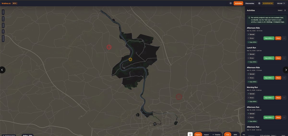
Kraina sits somewhere else in that space. It is a web-based platform built around a fog-of-war mechanic. Instead of treating the map as a record of where you have been, it treats it more like something you are gradually uncovering and maintaining.
How Kraina works
Kraina currently syncs through Strava and also supports manual GPX uploads. When an activity is imported, the route does not just appear as a line on the map. It clears a visible corridor through the fog along the recorded track. That is the basic idea, and it changes the feel of the map more than you might expect.
One of the more interesting mechanics is loop closure. If a route forms a closed shape, Kraina can reveal not just the corridor along the route itself but also the enclosed area within it. In practice, that changes the logic of route planning. Instead of simply adding one more unexplored street, there is a reason to circle a park, neighbourhood or forest edge and open up the whole area in one go.
Rolling fog, weekly missions and expeditions
Kraina tries to deal with the “what’s next?” problem through rolling fog. Revealed areas do not have to stay open forever. If a user stays away from a particular zone for long enough, fog can gradually creep back in. That changes the model from one-time discovery to something closer to upkeep.
Weekly missions are recurring geo-goals generated based on the user’s heartland — essentially, their home area inferred from activity history. They tend to sit just outside the user’s usual routine, which makes them feel more deliberate.
Expeditions are longer-range exploration goals aimed at activity beyond the user’s normal zone. Reaching a more distant point in the fog can reveal a set area around it, even without closing a loop. That gives longer rides or runs a clearer purpose than simply adding distance for its own sake.
What Kraina is – and is not
Kraina is not trying to replace TrainingPeaks, Intervals.icu or Garmin Connect. It is not a training analysis platform. What it adds is simpler: a spatial game layer on top of ordinary GPS activity data.
- A fog-of-war map rather than a static heatmap
- Territory and route shape rather than square collection
- Repeated engagement through rolling fog rather than one-time unlocks
- Map-based goals rather than purely metric ones
This is a tool for people who want a better answer to the question: where should I go next?
Data handling and privacy
Kraina respects Strava Privacy Zones. If part of a route is hidden in the source Strava data, Kraina does not attempt to reconstruct it or redraw it. Hidden sections are therefore not used for artificial loop closure or territory reveal.
Things to note
- Solo-first: There is no multiplayer mode, no club-versus-club territory system. Kraina is deliberately built as a PvE-style experience centred on your own map.
- Web-only: The product currently runs as a responsive web platform. There are no native iOS or Android apps at this stage.
- Current status: At the time of writing, it has 500+ registered users and almost 60,000 synced activities.
Summary
Kraina is not just another heatmap, nor simply another way to collect tiles. The interesting part is that it treats route history as something active: territory can be revealed, revisited and gradually lost again, rather than simply recorded. For Strava users who have stopped getting much out of standard heatmaps or static grid mechanics, that is a more interesting model than it might sound at first glance.
Kraina is currently live at kraina.cc.
Author: KRAINA
Last Updated on 28 May 2026 by the5krunner
My favourite kit and nutrition
- Injinji – Runners protect your toes. Avoid discomfort and minor injury. Run more. run faster. I use them.
- Garmin 90-degree charging adapter — the small adapter that keeps your charging cables tidy. Essential for race day. I use one.
- Garmin charging puck — the fastest and most reliable way to top up your Garmin before a session. I use one.
- Ravemen FR300 — front light that mounts directly under your Garmin or Wahoo head unit. Keeps your bars clean and your beam pointed where it matters. I use one.
- Body Glide – The Blue anti-chafe stick that all swimmers and many runners use. I use it.
- Maurten — the race nutrition trusted by elite athletes. Gels and drink mix engineered to be easy on the stomach. I use them.
- Garmin Varia RTL515 — radar rear light that alerts you to vehicles approaching from behind. Pairs with your Edge or Garmin watch. I use this model.
- Favero Assioma Pro RS2 — the power meter pedals most serious cyclists end up choosing. Accurate, easy to move between bikes. I use this model.
Reader-Powered Content

This content is not sponsored. It’s mostly me behind the labour of love, which is this site, and I appreciate everyone who supports it.
Support the site: Follow (free, fewer ads) · Subscribe (paid, ad-free) · Buy Me A Coffee ❤️
All articles are written by real people, fact-checked, and verified for originality. See the Editorial Policy. FTC: Affiliate Disclosure — some links pay commission. As an Amazon Associate, I earn from qualifying purchases.
tfk is the founder and author of the5krunner, an independent endurance sports technology publication. With 20 years of hands-on testing of GPS watches and wearables, and competing in triathlons at an international age-group level, tfk provides in-depth expert analysis of fitness technology for serious athletes and endurance sport competitors. ID
